Fun easing surf, strong S/SW swell Sunday/Monday
Southern Tasmania Surf Forecast by Craig Brokensha (issued Wednesday 11th January)
Sign up to Swellnet’s newsletter and receive the South Arm Forecaster Notes and latest news sent directly to your inbox. Upon signup you'll also enter the draw to win a surf trip to P-Pass for you and a mate. It doesn’t get much easier so click HERE to sign up now.
Best Days: Thursday morning, Friday morning, Sunday and Monday
Recap
Tiny surf yesterday, while today some new W/SW swell started to show, building considerably into this afternoon with gusty W'ly winds.
This week and weekend (Jan 12 - 15)
This morning a very intense low passed under us, generating this afternoon's spike in W/SW swell.
This low has since moved off to the east, leaving a trailing fetch of strong W/SW winds on its tail.
 This should produce some reinforcing W/SW swell for tomorrow afternoon, with a drop in size from 2ft to possibly 3ft, fading from a smaller 2ft on the sets Friday morning.
A morning offshore NW wind is expected tomorrow, ahead of SE sea breezes while Friday should see N/NE winds ahead of a late W'ly change.
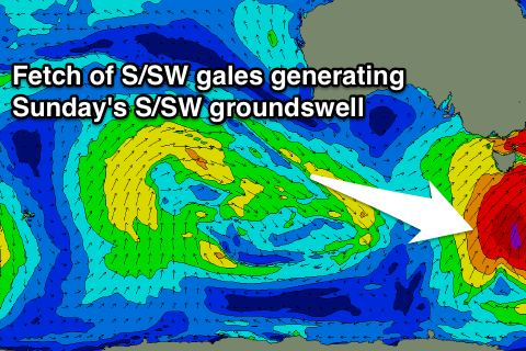
Into the weekend we've got a vigorous mid-latitude low tracking across us from the west.
Most of the lifespan of this low will be too far north but as it crosses us Saturday, a fetch of gale to severe-gale S/SW winds will be projected up through our southern swell window, generating a moderate to large sized S/SW groundswell for Sunday.
We're not expected to see any real size at all Saturday until late in the day, with winds and the swell being too west.
Sunday however should reveal the S/SW swell, building from 3-4ft during the morning to the 5ft range into the afternoon.
Steadily easing surf from 3-4ft is then due Monday, with small levels of lingering S/SE swell Tuesday and Wednesday.
Winds on Saturday will swing from a strong W/NW'ly around to the W/SW at some stage through the afternoon, with W/SW winds Sunday, possibly tending W/NW into the mid-late afternoon. Monday looks clean with offshore NW winds ahead of SE sea breezes.
We'll confirm this and the size of the S/SE swell on Friday though.

