Rapid increase in swell Wednesday, the same Saturday
Southern Tasmania Surf Forecast by Craig Brokensha (issued Monday 9th January)
Sign up to Swellnet’s newsletter and receive the South Arm Forecaster Notes and latest news sent directly to your inbox. Upon signup you'll also enter the draw to win a surf trip to P-Pass for you and a mate. It doesn’t get much easier so click HERE to sign up now.
Best Days: Wednesday afternoon protected spots, early Thursday, early Friday, Sunday morning protected spots
Recap
A small fun swell for Saturday morning with offshore winds, fading through the day and tiny into yesterday and today.
This week (Jan 10 - 13)
Tiny surf should continue tomorrow but into Wednesday an intense mid-latitude low passing under us will generate a fetch of severe-gale to storm-force W/SW winds through our western swell window.
The low will track very fast which isn't ideal, but the strength of the winds should still produce a kick in W/SW swell Wednesday afternoon, building rapidly to 3ft across Clifton with an early NW'ly giving into strong W/SW winds.
Offshore NW winds are due again early Thursday but the swell will recede rapidly from 2ft to maybe 3ft, smaller and 1-2ft Friday morning.
This weekend onwards (Jan 14 onwards)
 We've got a significant cold outbreak forecast to occur west of us on Friday with a fetch of gale to severe-gale W/SW winds initially being too far north.
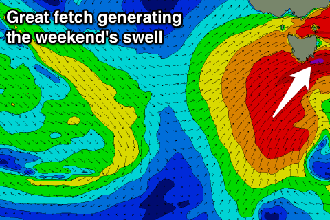
As the system moves east though, a tight fetch of severe-gales will be generated right under us Saturday afternoon, tending SW into the evening.
This should produce a solid increase in W/SW swell later Saturday, reaching 3ft by late and then easing slowly from 3-4ft Sunday morning.
Winds unfortunately look to be onshore through this swell event, including Sunday morning, but we'll confirm this Wednesday.

