Tiny with a small SE swell early next week
Southern Tasmania Surf Forecast by Craig Brokensha (issued Friday 30th December)
Sign up to Swellnet’s newsletter and receive the South Arm Forecaster Notes and latest news sent directly to your inbox. Upon signup you'll also enter the draw to win a surf trip to P-Pass for you and a mate. It doesn’t get much easier so click HERE to sign up now.
Best Days: Early Tuesday
Recap
A continuation of tiny surf across the coast, best left for beginners.
This weekend and next week (Dec 31 – Jan 6)
 Tiny surf is expected to continue tomorrow and Sunday, with a very long-range W/SW groundswell not expected to provide much over 1ft.
An onshore change that was due to bring some windswell Monday has been downgraded further with it falling apart as it approaches over the coming days.
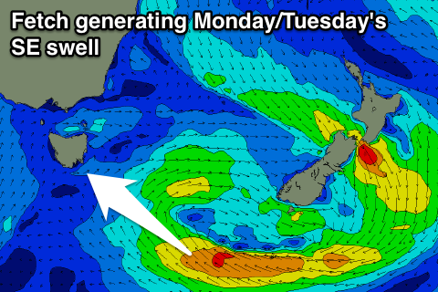
We've got some funky SE swell on the cards now though, as a trough slowly drifting east towards New Zealand aims a fetch of strong to gale-force E/SE winds through our south-eastern swell window Saturday afternoon through Sunday afternoon.
The swell should arrive Monday afternoon, reaching 2ft across Clifton and then holding a similar size Tuesday morning.
A drop in size is due through the afternoon, tiny into Wednesday. An inconsistent W/SW groundswell is due Wednesday morning from a distant fetch of W/NW winds, and we may see 1-1.5ft sets across Clifton.
Winds on Monday will be onshore, but Tuesday morning should see a morning W/NW'ly before swinging back onshore.
Later in the week a better SW groundswell is possible from a small intense low forming to our south-west, but we'll have another look at this Monday. Have a great weekend and Happy New Year!

