Thursday morning the only chance for a wave
Southern Tasmania Surf Forecast by Craig Brokensha (issued Wednesday 21st December)
Sign up to Swellnet’s newsletter and receive the South Arm Forecaster Notes and latest news sent directly to your inbox. Upon signup you'll also enter the draw to win a surf trip to P-Pass for you and a mate. It doesn’t get much easier so click HERE to sign up now.
Best Days: Early Thursday
Recap
Small 1-2ft waves out of the south yesterday morning, while today a tiny bumpy windswell was on the build, with not much size early, but 1-2ft sets are due into this afternoon.
This week and weekend (Dec 22 - 25)
Currently a weakening front is passing under us, and the small lift in swell due through today will ease back through tomorrow.
Hopefully there'll still be 1-2ft sets on offer early but it might be more around 1-1.5ft after this morning's reports.
Conditions will be cleaner with a light NW offshore wind and afternoon SE sea breeze.
From Friday tiny waves are then due with no love due over the Christmas period.
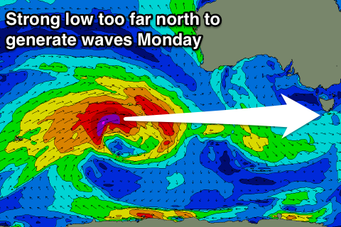
 Monday afternoon a very inconsistent long-period W'ly groundswell is due, but the low generating the swell will be too far north and out of our main swell window to generate anything above 1ft.
A S'ly change will create poor conditions in any case.
Next week onwards (Dec 27 onwards)
Monday afternoon's change will be linked to a trough moving across us and stalling low to our south-east, with a fetch of strong S/SE winds being aimed into us through Monday evening and Tuesday morning.
An onshore S/SE swell to 1-2ft is expected, fading Wednesday as winds swing more NE.
Longer term besides some small to tiny E/SE swell there's nothing major on the cards.

