Clean easing swell tomorrow, better swells from late next week
Southern Tasmania Surf Forecast by Craig Brokensha (issued Friday 9th December)
Best Days: Saturday morning, early Monday, later next week
Recap
Nothing to surf yesterday, while today a new S/SW swell was on the build with bumpy 2ft waves early this morning, increasing further this afternoon.
This weekend and next week (Dec 10 - 16)
The frontal system responsible for today's building S/SW swell is currently moving off to the east and with this we'll see the swell easing from a more SW direction tomorrow morning, back from 2ft+ early.
An offshore NW wind is due, tending W/NW through the day keeping conditions fairly clean.
The small W/SW swell due into Sunday afternoon and more so Monday is looking a little smaller with the post-frontal fetch of W/SW winds only being in the 25-30kt range.
With this a small 1-2ft of W/SW swell is due Sunday afternoon but with onshore winds, easing from a similar size Monday morning with an offshore.
Tiny waves are then due until later in the week.
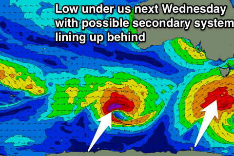
 As talked about last update, a new swell is due mid-late week from a deepening polar low south-west of us Wednesday.
An initial broad fetch of strong W/SW winds are due to be produced, strengthening to the gale-force range as the low moves under us.
A small building W/SW swell is expected Wednesday afternoon but only to 2ft or so, with some stronger groundswell Thursday reaching 3ft or so.
A secondary low may be seen to generate a larger swell next Sunday, but we'll look at this again on Monday. Have a great weekend!

