Small swells to end the week, better W/SW swell for the weekend
Southern Tasmania Surf Forecast by Craig Brokensha (issued Wednesday 30th November)
Best Days: Beginners Thursday morning, Friday morning, Sunday, Monday morning, Tuesday morning
Recap
Small 1-2ft waves yesterday ahead of a new S'ly swell through the afternoon but with onshore winds.
This morning was a little disappointing with only 1-1.5ft sets reported around Clifton out of the south.
This week and weekend (Dec 1 - 4)
Today's S'ly swell should ease back through tomorrow, with 1-1.5ft sets hopefully still on offer.
A morning offshore wind is expected ahead of fresher E/NE breezes into the afternoon.
Our small inconsistent W/SW groundswell for Friday morning is still on track, generated earlier this week south-west of WA. This should offer 1-2ft sets before easing during the day and conditions look to be clean through the morning, with a W/NW change into the afternoon.
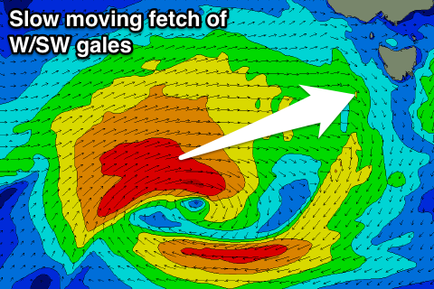
 The weekend's good W/SW groundswell is also still on track, with a strong low due to form just within out swell window, south of WA this evening.
The low will move very slowly south and east, aiming a fetch of gale to severe-gale W/SW winds through our western swell window.
We're probably now looking at a peak in swell Sunday morning, with Saturday due to see the swell building to 2ft through the afternoon, easing from 2-3ft dawn Sunday.
A morning offshore is expected Saturday ahead of sea breezes, and then NW tending NE winds Sunday.
Next week onwards (Dec 5 onwards)
Monday should start tiny, but a strengthening low to our south is forecast to generate a fetch of strong to gale-force W'ly winds directly under us.
While not ideal it should produce a late kick in size Monday and Tuesday morning to 1-2ft.
Some small S'ly swell may be seen later week from the base of the low, but we'll review this Friday.

