Swell this week but with onshore winds, better weekend
Southern Tasmania Surf Forecast by Craig Brokensha (issued Monday 14th November)
Best Days: No good days until the weekend
Recap
Some small lumpy waves to kick off the weekend Saturday before winds really kicked in and swung more SE into Sunday, creating poor conditions. The low stayed a little further north than ideal to generate any major swell for us, and with this we've seen tiny onshore waves persisting today.
This weekend and next week (Nov 15 - 18)
Tomorrow is expected to start out tiny, but into the afternoon and Wednesday a mix of long-range W/SW groundswell and shorter-range mid-period W/SW swell are due.
The long-range energy should reach 1-2ft tomorrow afternoon but winds will be onshore from the W/SW, as a small weak low generating the mid-period energy moves in.
We should see a peak Wednesday to 2ft but SW winds look to linger in the wake of the low pushing north-east into the Tasman Sea.
Thursday will be cleaner with N'ly offshores but no size is expected, with Wednesday's swell fading through the day, down further from 1ft.
Friday will be even smaller.
 This weekend onwards (Nov 19 onwards)
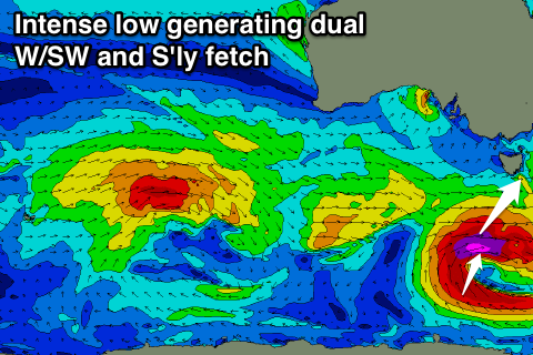
The weekend is looking interesting, as we're set to see a vigorous polar low form late in our swell window, to our south-southwest Friday.
A quick burst of severe-gale W/SW winds will be produced in our southern swell window, generating a new S/SW groundswell for Saturday.
It looks like the models are under-forecasting the size from this low, with Clifton set to offer 2ft sets.
We should also see the swell hang in Sunday as a secondary fetch of S/SW gales wrapping around the base of the low generate a secondary S'ly swell for Sunday, but we'll confirm this on Wednesday.
Winds are looking decent Saturday morning and more of Sunday, but lets have another look Wednesday.

