Tiny surf until mid-next week
Southern Tasmania Surf Forecast by Craig Brokensha (issued Friday 30th September)
Best Days: Possibly Saturdya morning, no good days then until Wednesday
Recap
Tiny lumpy waves yesterday morning with onshore stormy 1ft windswell waves today.
This weekend and next week (Oct 1 - 7)
Tomorrow morning is the best of the weekend.
We should see a small lift in SW groundswell to 1ft to possibly 2ft early, easing through the day.
A N-N/NE wind is due, favouring swell magnets before tending weak onshore into the afternoon.
Sunday is then due to be tiny with NW tending N/NE winds.
 Into early next week the surf will remain tiny, with a series of W'ly swell due to hit the West Coast Monday and Tuesday being generated too far north to get into Clifton.
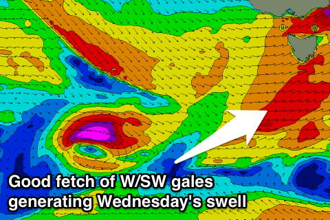
It won't be until all the activity shifts across us on Tuesday evening that we'll see a fetch of W/SW gales generated right under us. This will be short-lived and as a result a short-lived spike in W/SW swell is die Wednesday morning to 2ft easing into the afternoon.
A more distant W/SW groundswell to a similar 2ft on the sets is due Thursday, fading into Friday.
A new pulse of W/SW groundswell is due Friday afternoon though from an intense mid-latitude dropping east-southeast through our swell window mid next week, generating a tight fetch of severe-gale to storm-force W/NW winds. This should see 2ft waves again across Clifton.
Now winds will be favourable for the most part next week with NW-W/NW breezes, with W/SW changes Wednesday afternoon and possibly Friday afternoon.
One final sneaky S'ly swell may be seen across the coast later Thursday and Friday from fetch of S'ly gales forming on the polar shelf Tuesday evening. More on this next week. Have a great weekend!

