Tiny run of swell, better Thursday
Southern Tasmania Surf Forecast by Craig Brokensha (issued Wednesday 3rd August)
Best Days: Swell magnets to SE swell tomorrow late morning through Sunday morning, Thursday
Recap
Onshore 1-1.5ft waves yesterday, while today a slight kick in swell was seen with 2ft sets. It may be SE swell but it's hard to tell without being on location.
This weekend and next week (Aug 6 - 12)
Our small pulse of SE groundswell due tomorrow from a poorly aligned polar front pushing up towards New Zealand into the Tasman Sea is still showing on the charts.
While not ideally aligned the persistent activity to our south-east may see us just bump over into that surfable range to 1-1.5ft when it arrives mid-morning tomorrow. More exposed spots will be better, and more so the East Coast.
Offshore NW winds are due, tending variable through the afternoon.
Come Sunday the SE swell is expected to ease from 1-1.5ft under N/NW tending NE winds.
Unfortunately for early next week there's nothing significant at all with, tiny and inconsistent W/SW swells struggling to get above 1ft Monday morning and Tuesday morning.
 Into the end of the week though some better W/SW groundswell should be seen.
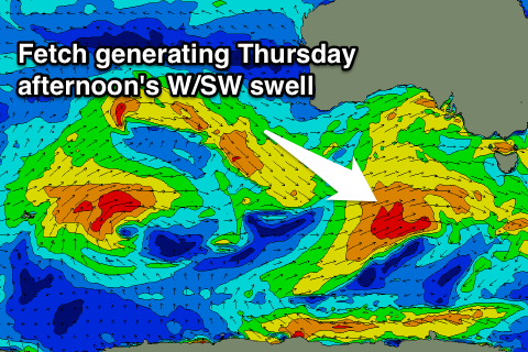
Firstly an inconsistent and acute long-period W/SW groundswell is due to build Wednesday afternoon, generated by a tight fetch of severe-gale to storm-force W'ly winds wrapping around the core of a mid-latitude low stalling south of WA.
This low will then weaken and push towards us in the form of a frontal system, with a closer fetch of W/SW gales generating a secondary W/SW swell for Thursday.
Size wise a slight increase to 1-2ft may be seen Wednesday afternoon, with a better increase Thursday afternoon to 2ft+.
Conditions look favourable as well with W/NW offshores Wednesday and Thursday, back to the N/NW Friday. But we'll look at this closer Monday. Have a great weekend!

