Small to tiny and dicey swells
Southern Tasmania Surf Forecast by Craig Brokensha (issued Monday 30th November)
Best Days: Mid-late Tuesday morning, early Wednesday, Thursday morning
Recap
The swell seen at the end of the week held in a touch better than expected Saturday morning with 2-3ft sets under light offshore winds, but conditions were a little lumpy and wobbly.
The swell really dropped through the day though, leaving tiny 1-1.5ft waves into Sunday. Tiny waves persisted into today with favourable winds for more exposed coasts.
This week (Dec 1 - 4)
A very slight kick in inconsistent W/SW groundswell is due through tomorrow followed by a secondary pulse Wednesday, from a couple of weak lows moving through our swell window late last week and over the weekend.
1ft to maybe 2ft sets are expected tomorrow, with Wednesday now set to come in at a similar size. Tomorrow morning is likely to still be tiny.
 Early and average W'ly winds are due to tend more NW through the morning ahead of afternoon sea breezes, and then early NW tending gusty SW winds Wednesday.
The W/SW swell that was also due to be in the water Wednesday has now formed too far north to really impact our region.
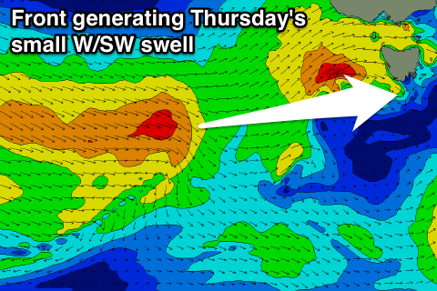
A secondary weak front trailing the initial system is due to produce a slightly better W/SW pulse for Thursday morning to 1-2ft across Clifton with W/NW tending W/SW winds before fading into Friday.
The longer term remains void of any major swell activity but the coast won't go flat with small to tiny levels of background swell due into Saturday and Sunday, and possibly early next week. More on this Wednesday.

