Good onshore swell tomorrow, cleaner as it eases early Wednesday
Southern Tasmania Surf Forecast by Craig Brokensha (issued Monday 9th November)
Best Days: Early Wednesday, Thursday morning, Saturday morning
Recap
Suss winds and a drop in swell back to 1-1.5ft Saturday, while Sunday was ideal for beginners with the swell hanging in at 1-1.5ft with morning offshore winds.
Today the beginnings of a new inconsistent long-range W/SW groundswell was starting to build with clean 1-2ft sets this morning, but a further kick to 2-3ft should have been seen this afternoon.
This week and weekend (Nov 10 - 15)
Today's inconsistent W/SW groundswell will be replaced by a bigger, more consistent and better aligned SW swell through tomorrow, produced by strong trailing polar frontal activity behind the 'bombing low' that generated today's swell.
Clifton should build to a good 3ft+ through tomorrow afternoon but winds are looking suss all day. A fresh W/SW breeze is likely to spoil conditions through all of tomorrow, with the chance of an early W'ly very slim.
Wednesday should be cleaner with an early W/NW breeze as the swell eases from the 3ft range, but get in sooner rather than later as onshore winds are due to kick in mid-late morning, tending more SE into the afternoon.
Thursday will be cleaner with N/NW tending N/NE winds but a fading swell from 1-2ft or so.
 Come Friday clean tiny waves are due through the morning, with an afternoon increase in long-range and very westerly W/SW due across Clifton.
This late pulse of groundswell may reach 1-2ft but with an onshore SW change spoiling conditions.
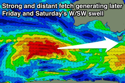
A peak is due Saturday morning though, with the swell being produced by a strong and powerful polar low firing up in the Heard Island region today, projecting a fetch of gale to sub-severe-gale W/SW winds towards WA. This low will then dip east-southeast through our swell window while weakening into Wednesday evening.
This isn't the most ideal swell direction for us, but the size of the system should help produce inconsistent 2ft waves for Saturday morning with NW tending W/SW winds late afternoon.
Longer term there's nothing too significant at all on the cards with the storm track becoming quiet, although persistent, with background energy between 1ft and 2ft likely through next week. More on this Wednesday.

