Fun waves for the coming week
Southern Tasmania Surf Forecast by Craig Brokensha (issued Monday 5th October)
Best Days: Tuesday, Wednesday afternoon, Thursday morning, Friday morning, Saturday
Recap
Kick in swell to 2-3ft Saturday but with poor winds, while Sunday was cleaner and fun in the 2ft range. Today long-range W/SW swell kept the coast around 2ft this morning with a hot N'ly breeze which has since shifted more W/NW.
This week (Oct 6 – 9)
Into tomorrow we're due to see a large W'ly groundswell impacting the west coast of the state, but it's direction will limit size across the South Arm.
The source of this swell was a very strong and elongated frontal system tracking unfavourably east-southeast from the Indian Ocean, under WA and then under us today.
Satellite observations have picked up sustained winds in the 50kt range, and this should result in a strong W/SW groundswell tomorrow in the 2-3ft range across Clifton (much larger at exposed breaks).
Winds will be light from the NW early before strengthening from the NW and then tending W/NW into the afternoon.
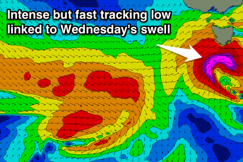
 Into Wednesday a fresh pulse of short-range W/SW swell is due as a vigorous low forming right on our doorstep aims a fetch of severe-gale to storm-force W/SW tending SW winds off our south coast Tuesday evening and early Wednesday.
This should kick up a short-lived pulse to 3ft across Clifton, easing later in the afternoon to be replaced by a W/SW groundswell Thursday in the 2ft+ range through the afternoon. This will be generated by another unfavourably tracking frontal system moving in from the west over the coming days.
Back to the winds Wednesday though and a W/SW breeze is unfortunately due through the morning in the wake of the vigorous low, but a swing to the W is due through the afternoon.
Thursday and Friday should then see NW offshores ahead of SE sea breezes.
This weekend onwards (Oct 10 onwards)
A flukey pulse of S/SW swell is due through Saturday from a a very intense but small polar low firing up to our south-west Thursday. A pre-frontal fetch of severe-gale to storm-force W/NW winds, tending more W'ly as it pushes east will be generated in our southern swell window.
Again the track isn't ideal but the direction good, with a kick to the 2ft range due through the morning across Clifton, becoming tiny into Sunday with offshore winds for most of the weekend.
Longer term there's nothing major on the cards, so make the most of the coming days of swell.


Comments
Gibbo on the hunt today..