Fun swell from Wednesday with generally clean conditions
Southern Tasmania Surf Forecast by Craig Brokensha (issued Monday 14th September)
Best Days: Wednesday, Thursday morning, Saturday, Sunday morning, Monday
Recap
Tiny clean waves Saturday morning, while a new pulse of SW swell for later in the day and Sunday morning came in at a good fun 2ft across Clifton.
Today, the swell held a good 2ft across Clifton with offshores, with the long-range W/SW groundswell looking to have possibly come in a little better than expected.
This week and weekend (Sep 15 – 20)
Tomorrow is expected to be tiny with today's W/SW groundswell expected to fade from a tiny 1-1.5ft, but we've got plenty more swell on the cards from Wednesday through the end of the week. If you're looking for a surf tomorrow, go early as a NW breeze will give way to an onshore change through the morning.
Into Wednesday a good SW groundswell is due to fill in, generated today and tomorrow by a good fetch of W/SW gales along the polar shelf.
A moderate sized SW groundswell is due, with it expected to build to 3ft through the morning Wednesday and then ease slightly from 3ft or so Thursday morning.
Some secondary SW groundswell energy is due later Thursday and Friday across Clifton though, as a strong pre-frontal fetch of W/NW gales swings in from the Indian Ocean and strengthens right under us.
This should produce another good SW groundswell pulse for late Thursday to 2-3ft, holding Friday around 2-3ft and then easing back through Saturday from 2ft to possibly 3ft.
 Winds over this period of swell should be generally good, early NW both Wednesday and Thursday before shifting onshore, while Friday looks a little dicey with a possible lingering SW'ly onshore.
Saturday should see winds swinging back to the NW, with Sunday morning offshore ahead of a SW change.
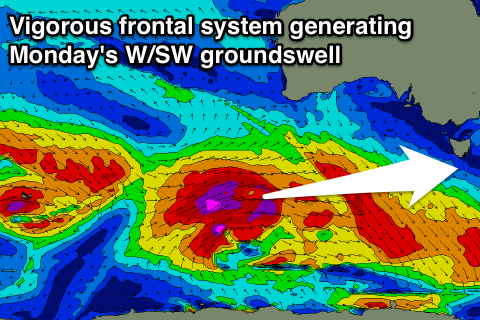
This SW change will be linked to a vigorous polar frontal progression pushing in from the west and with it a moderate sized and long-period W/SW groundswell.
A fetch of severe-gale to storm-force W/SW winds will be aimed through our western swell window, before the front races ahead of the swell and pushes in through Sunday.
Initially a small increase in W//SW groundswell is due Sunday morning from a strong pre-frontal fetch of gales, but only to 2ft or so, with the swell proper moving in Monday and peaking to the 3ft range across Clifton with NW winds.
Longer term a follow up swell is due Tuesday/Wednesday but well review this again Wednesday.

