Fun swell Wednesday, better W/SW swells Sunday/Monday
Southern Tasmania Surf Forecast by Craig Brokensha (issued Monday 22nd June)
Best Days: Wednesday, Thursday morning, Sunday, Monday
Recap
Slow start to Saturday and only reported as 2-3ft, but large strong sets filled in through the day under offshore winds.
A reinforcing SW groundswell for Sunday provided 3-4ft waves for most of the day under clear sunny skies and light offshore tending variable winds.
A drop in size was seen overnight with much smaller 1-2ft waves left into this morning.
This week and weekend (Jun 20 – 26)
Tomorrow will be tiny, but a late increase in new SW groundswell is on the cards to 2ft, peaking Wednesday to 2-3ft. This has been generated by a polar low pushing in from the west over the last couple of days and with offshore winds, Wednesday's the pick.
The swell should ease into Thursday from a small 2ft and then become tiny Friday.
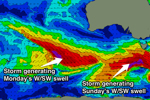
Into the weekend, we've got a very tricky forecast, with some long-range and very inconsistent W/SW groundswell due to impact the state from all the activity in the Indian Ocean.
 We're not due to see any real size of the initial stages of the frontal progression Saturday, but come Sunday a mix of very inconsistent energy from an expansive fetch of severe-gale W/SW winds developing south-west of WA tomorrow and Wednesday.
The swell from this should build Sunday to a very inconsistent but long-lined 3ft+ across Clifton.
Over-riding this long-range swell though will be a short-range and stronger W/SW groundswell from a deepening polar front pushing in from the west Friday and Saturday.
A fetch of severe-gale W/SW winds will be produced through our swell window, generating a large W/SW groundswell, peaking through the middle of the day/afternoon Sunday to 3-4ft across Clifton.
Conditions are looking good as well with a fresh to strong W/NW breeze.
Into Monday the swell should remain solid as another but less favourably aligned fetch of pre-frontal W/NW gales pushes through Sunday evening, keeping 3ft+ sets kicking into Monday under W/NW winds.
We'll have a closer look at this on Wednesday though, as the models are moving slightly on the timing and strength of these swell producing fronts.sss

