Large clean swell tomorrow morning, easing Sunday
Southern Tasmania Surf Forecast by Craig Brokensha (issued Friday 19th June)
Best Days: Saturday, Sunday, Monday morning, Wednesday
Recap
Poor junky windswell with onshores yesterday and then nicer cleaner 1-2ft waves with a mix of swells today.
This weekend and next week (Jun 20 – 26)
There's been no real change to the large and powerful SW groundswell due to peak tomorrow morning across the region, with Clifton due to come in at 4-6ft at dawn, before easing steadily and dropping back further from the 3ft range Sunday morning.
Our reinforcing swell is due earlier now, with the front generating it racing in quick, with it arriving during the afternoon and keeping 3ft sets hitting Clifton.
 The faster movement of the front will bring less favourable winds tomorrow afternoon though, with a morning NW'ly due to swing W/SW through the afternoon.
Sunday looks great with N/NW tending variable breezes.
Into Monday the swell should drop steadily from 2ft across Clifton under strengthening N/NW tending N'ly winds.
Tuesday is then due to be flat.
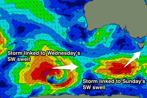
Wednesday's pulse of SW groundswell has been downgraded a touch unfortunately with the polar low generating it, not expected to be as strong as forecast on Wednesday.
Still this low, forming south-west of WA this evening, should still generate a persistent fetch of SW tending W/SW gales through our swell window over the weekend and early next week, producing a fun SW groundswell for later Tuesday (likely 2ft), peaking Wednesday morning to 2-3ft across Clifton. Winds should be OK and light N'ly tending N/NE Wednesday, favouring eastern ends of beaches.
Longer term, the very strong and broad frontal activity occurring in the Indian Ocean will have to effect on Clifton, with it being too north in latitude and too far away. Our West Coast will see large waves though..
Into the weekend we may see the activity moving across to us along with the Long Wave Trough, but we'll review this again Monday. Have a great weekend!

