Large clean swell Saturday, smaller for the rest of the period
Southern Tasmania Surf Forecast by Craig Brokensha (issued Wednesday 17th June)
Best Days: Saturday, Sunday, Monday morning, Tuesday morning
Recap
Tiny surf yesterday, continuing into today but with a fresh onshore wind, creating poor conditions.

This week and weekend (Jun 18 – 21)
Today's onshore change will kick up a poor and small windswell for tomorrow but with persistent onshore S/SE winds.
Friday will be no better with a tiny swell and morning W/NW breeze ahead of an afternoon SW change.
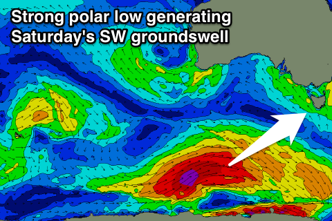
Our large and powerful SW groundswell due for Saturday is still well on track, with satellite observations confirming a fetch of storm-force W/NW winds generated in our far swell window during the initial stages of the polar low generating it.
This low is now tracking east and will continue to generate a fetch of severe-gale W/SW winds through our swell window while projecting towards us over the coming days.
A large, powerful long-period SW groundswell will result, peaking Saturday morning to 4-6ft across Clifton, easing into the afternoon and further from the 3ft range Sunday.
Winds look great and offshore from the NW all day Saturday and then N/NW tending N'ly winds Sunday. Late in the day a new reinforcing SW groundswell is due generated by a secondary tight polar low firing up through our swell window, keeping 3ft sets hitting Clifton before easing Monday from 2ft+ or so.
Next week onwards (Jun 17 onwards)
Monday's easing swell will be met with fresh to strong N/NW winds, while another strong SW groundswell is due into Tuesday, generated by another strong polar frontal progression pushing in from the west over the weekend.
The size off this system looks to be less than that of Saturday's with 3-4ft+ sets likely across Clifton with early light winds ahead of a shallow onshore change.
Longer term there's nothing too major on the cards, but we'll have another look at this on Friday.

