Good W/SW swells with varying winds
Southern Tasmania Surf Forecast by Craig Brokensha (issued Friday 22nd May)
Best Days: Thursday for beginners, Friday afternoon, Saturday, early Sunday
Recap
Fun and small mix of swells to 2ft yesterday, with the S/SE swell being the more dominant feature today keeping 2ft sets hitting Clifton under all day offshores.
 This week and next week (May 28 – Jun 5)
Our current S/SE swell from a stalling low south of New Zealand earlier this week, is expected to fade off slowly through tomorrow from 1-1.5ft and further 1ft+ Friday morning.
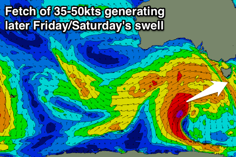
A new strong W/SW groundswell should take its place into Friday though, generated by a vigorous polar frontal progression that's currently south of WA.
A fetch of severe-gale W/SW winds are being generated on the edge of our swell window, and will continue to move more into our swell window through tomorrow as the system pushes further east.
A strong W/SW groundswell should result, building Friday afternoon to 2-3ft+ across Clifton, before easing from 3ft on the sets Saturday morning.
Winds should be offshore all day Friday and from the NW, so the afternoon is well worth a look. Saturday should then see NW tending W/NW winds, keeping conditions clean again.
A secondary pulse of strong W/SW groundswell has now been upgraded, with a polar front developing to our south-west Friday evening. This will project a fetch of severe-gale SW winds north-east towards Victoria, on the edge of our swell window.
If this system was 1000km further east we'd see an easy 6-8ft of swell across Clifton, but instead we're due to see W/SW swell energy, building through Sunday and peaking into the afternoon to 3-5ft.
Into Monday the swell will ease but a better aligned S/SW swell is due, generated on the tail of the polar front, with a fetch of strong to gale-force S/SW winds being projected up into us Sunday evening and Monday.
This should see Clifton easing from 3-4ft out of the W/SW Monday morning, with the S/SW swell for the afternoon to 2-3ft, easing from a similar size Tuesday morning.
Winds will unfortunately swing onshore through Sunday with a strong morning W/NW breeze, due to swing SW through the morning and then persist from the SW tending S/SW into Monday and possibly even Tuesday.
Longer term there's nothing major on the cards at all for our region, so make the most of the coming swells!

