Small SE swell and then better W/SW swell late week
Southern Tasmania Surf Forecast by Craig Brokensha (issued Friday 22nd May)
Best Days: Tuesday and Wednesday exposed spots to the SE, Friday before the change, Saturday, Sunday morning
Recap
Good solid 3ft waves with favourable winds Saturday morning, with an easing swell and all day offshores Sunday from 2-3ft. This morning the swell was on the ease from the smaller 2ft range under persistent offshore winds.
 This week (May 26 - 29)
The swell should continue to ease out of the SW tomorrow, but a new funky S/SE groundswell is due tomorrow, generated by a vigorous polar low that's currently sitting south of New Zealand.
This low produced a fetch of storm-force S'ly winds just on the edge of our swell window yesterday, with an inconsistent but strong S/SE groundswell due to spread out radially towards us for tomorrow.
Clifton should see infrequent 2ft+ sets through tomorrow and Wednesday morning, easing later, with bigger bombs at exposed south-east facing breaks.
Conditions look good with offshore NW tending variable winds tomorrow and then fresh to strong N/NW winds all day Wednesday.
Come Thursday and Friday there is still expected to be a trace of SE groundswell from the south-eastern flank of the low sitting south of New Zealand, but not to any considerable size.
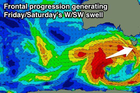
Of greater importance is a bigger W/SW groundswell due into the end of the week, generated by a vigorous polar frontal system moving in from the west and across us Friday.
The initial stages of this low will generate large swells for WA, SA and Vicco, but be on the edge of our swell window, but as it moves under the Bight Wednesday and Thursday, a fetch of gale to severe-gale W/SW winds will be aimed through our western swell window.
A good W/SW groundswell should be produced, building through Friday to the 3ft+ range by the afternoon. Winds look good early with a fresh N/NW'ly but a strong W/SW change is due late morning.
This weekend onwards (May 30 onwards)
The swell will drop away into Saturday from the 3ft range, further down into Sunday with favourable and persistent offshore winds.
Into early next week, a follow up polar frontal system approaching from our south is expected to kick up at least some moderate sized S/SW swell Monday/Tuesday but we'll have a closer look at this on Wednesday.

