Solid swells with average winds, cleaner over the weekend
Southern Tasmania Surf Forecast by Craig Brokensha (issued Wednesday 20th May)
Best Days: Possible dawn tomorrow, Friday morning, Saturday morning, Sunday, Monday for beginners, Wednesday, later next week
Recap
Clean easing surf around 2ft yesterday with favourable winds, while this morning the swell bottomed out with onshore winds. A late and strong kick in groundswell was seen though, with some great readings on the Cape Sorell wave buoy, but with those onshore S'ly winds.
 This week and weekend (May 21 - 24)
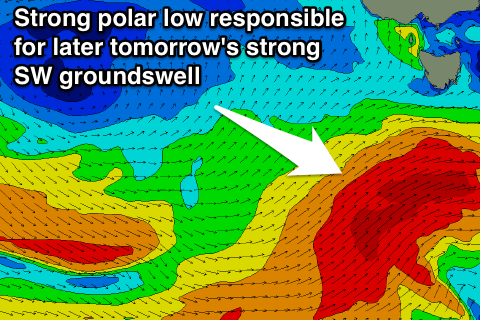
This afternoon's increase in strong SW groundswell will ease back into tomorrow morning, only to be followed up by a larger and stronger increase in SW groundswell during the afternoon.
The front linked to this swell is currently to our south-west, aiming a fetch of severe-gale SW winds through our swell window.
This swell should build to a strong 4-5ft during the mid-late afternoon across Clifton, but winds will spoil the party with a fresh to strong but easing S/SW tending SW breeze due. There is a chance for a W'ly wind at dawn, with 3-4ft of swell leftover from today, but keep an eye on the local winds observations.
Friday should see cleaner conditions as the SW swell drops from 3-4ft with morning W/NW winds before shifting back to the W/SW into the afternoon.
Into the weekend, the swell will continue to ease, but some trailing and strong frontal activity in the wake of the vigorous polar low should keep easy 3ft sets hitting Clifton Saturday before easing back from 2-3ft Sunday.
Winds should be good again Saturday morning, with NW tending variable breezes Sunday.
Next week onwards (May 25 onwards)
The easing trend should continue into the weekend, with the swell dropping from 1-2ft Monday under offshore winds, becoming tiny Tuesday.
A small and inconsistent W/SW groundswell to 1-2ft is expected possibly late Tuesday but more so Wednesday, generated by a south-east dipping polar frontal progression to the south-west of WA over the weekend.
Longer term a better W/SW groundswell is on the cards for later in the week, but we'll have a closer look at this on Friday.

