Large easing SSW swell, good waves next week
Southern Tasmania Surf Forecast by Craig Brokensha (issued Wednesday 13th May)
Best Days: Every day over the coming period
Recap
Small 1-2ft waves yesterday morning ahead of a strong kick in W/SW groundswell later in the day as winds started to swing more W/SW on dark.
This W/SW groundswell was replaced by a better SW groundswell this morning to 3-5ft across Clifton, but this should of then kicked in size a touch more this afternoon as a vigorous frontal system pushed up and into us. Conditions were only good in protected locations though with a fresh to strong W/NW tending W/SW breeze.
This week and weekend (May 14 - 17)
This afternoon's increase in SW swell should swing more S/SW in direction overnight and ease through tomorrow in the wake of the strong cold front pushing up and into the Tasman Sea.
Clifton should ease from 4-5ft but conditions look average with a strong but easing SW wind.
Our new pulse of S/SE groundswell for Friday has been downgraded a touch with the fetch of severe-gale to storm-force S'ly winds being generated to out south-southeast now forecast to form a little further east and not be as strong.
Still we should see a fun pulse of S/SE swell through the day to an inconsistent 3ft to occasionally 4ft across Clifton. An early W/NW wind is due ahead of a swing back to the W/SW into the late morning.
Into the weekend the S/SE groundswell will fade away but a fun new SW groundswell is due from a polar front pushing east along the polar shelf over the coming days.
This should kick Clifton back to 2-3ft through the day Saturday (possibly undersized early) before easing back from the 2ft range Sunday.
Winds will be great and offshore from the NW both mornings and more W/NW into the afternoons.
 Monday onwards (May 18 onwards)
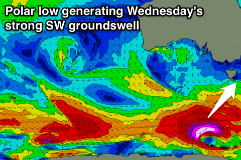
The westerly storm track will stay at polar latitudes through the weekend and into early next week, generating a couple of good SW groundswell pulses for our region.
The first on Monday afternoon should kick to 2-3ft again across Clifton but a stronger pulse is due Wednesday to 3-4ft+. Winds look favourable and offshore from the NW Monday while Wednesday should see N/NW tending NE winds.
Longer term the swell is expected to slowly drop away, but more on this Friday.

