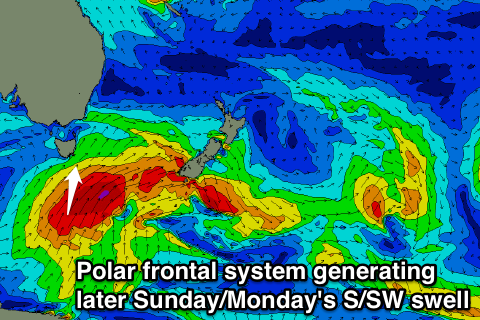
Large S/SW swell later Sunday/Monday morning
Southern Tasmania Surf Forecast by Craig Brokensha (issued Friday 10th April)
Best Days: Tomorrow morning for beginners, later Sunday protected spots, Monday morning most spots, Tuesday, Wednesday morning
Recap
Fun clean 2ft waves yesterday and this morning ahead of afternoon SE sea breezes.

This weekend and next week (Apr 11 - 17)
Tomorrow is expected to still be small to tiny but clean through most of the day with a NW'ly offshore ahead of an afternoon W/SW change.
Sunday and Monday's large S/SW groundswell has been downgraded a touch but in saying this, we should still see solid levels of swell pushing into the coast and hopefully enough for selected spots out of the wind.
The polar frontal system generating the swell is just a touch weaker and forming a touch further east than forecast earlier in the week, but we'll still see a fetch of S/SW gales projected up through our southern swell window tomorrow and Sunday morning.
The arrival time looks to be later Sunday with Clifton due to pulse late to 5-6ft on dark, although the morning should see a fun 2ft of SW groundswell.
A peak is due overnight, with the swell easing from the 5-6ft range Monday morning.
Winds will be fresh to strong from the W/SW tending S/SW Sunday favouring protected spots, and then light NW Monday morning ahead of S/SE sea breezes, which isn't ideal. Hopefully winds will be more variable Monday morning.
The swell should then tail away into the afternoon and further 3ft under N/NW tending NE winds.
Only small leftovers are then due into Wednesday with N/NW winds.
Longer term all the storm activity will be focussed into WA and north of our swell window later next week, with some small and infrequent W/SW swell possibly squeaking in from Saturday, but we'll look at this in more detail on Monday. Have a great weekend!

