Plenty of swell over the coming period
Southern Tasmania Surf Forecast by Craig Brokensha (issued Wednesday 25th March)
Best Days: Thursday working around the winds, Saturday morning, Monday, Tuesday
Recap
Monday's kick in SW groundswell eased back into yesterday, mixed in with a weaker windswell with 1-2ft waves across the coast. Today the swell was a tinier 1-1.5ft under light morning offshores.
This week (Mar 26 - 27)
Tomorrow's swell is looking really nice, generated by a strong polar frontal system that developed south-southwest of WA earlier this week. The polar front has since pushed east while weakening but maintaining a broad fetch of strong to gale-force W/SW winds in our swell window.
Clifton should come in at 2-3ft and winds are really tricky due to an intense mid-latitude low stalling to our north-west.
You'll have to play it by ear a little with dawn E/NE winds due to swing more N'ly through the morning and NW into the afternoon. This could all change though through the day due to the tricky nature of the system.
The SW groundswell should ease into Friday from 2ft and a junky S'ly windswell is due to be in the mix as the low pushes east across us, projecting a fetch of strong to gale-force S/SE tending S/SW winds into us. Don't expect any major size or quality though.

This weekend onwards (Mar 28 onwards)
A fun new SW groundswell is now on the cards for Saturday morning, generated today and tomorrow by a fetch of W/NW winds aimed mainly at the polar shelf. We should see some good SW groundswell spread up radially from this source, coming in at 2ft across Clifton Saturday morning before easing into the afternoon and further Sunday from 1-1.5ft.
Winds look good and offshore Saturday morning with a NW'ly before tending variable ahead of possible afternoon sea breezes.
Sunday should then also be clean with fresh N/NW winds ahead of a gusty W/SW change through the day.
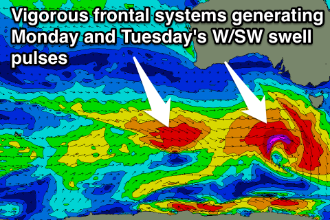
This change will be linked to a vigorous frontal system pushing in and across us, linked to a good W/SW groundswell due Monday.
The frontal system will develop south-west of WA and race east towards us, generating a fetch of gale to severe-gale W/SW winds through our swell window, followed up by a secondary system generating a less favourable W/NW fetch.
The fast track of the front isn't ideal but the strong core winds make up for this with a good pulse in size to 3ft on the sets across Clifton due Monday morning, with the secondary pulse coming in around the similar range on Tuesday morning.
Winds look good and from the NW to W/NW for the most part, but we'll have another look at this on Friday.

