Small swell pulses over the coming period
Southern Tasmania Surf Forecast by Craig Brokensha (issued Monday 23rd March)
Best Days: Tuesday morning, Thursday (winds pending), later Saturday for keen surfers, Sunday morning
Recap
A tricky and flukey W/SW swell due later Friday and Saturday morning came in under expectations Saturday morning with only a small 1-2ft wave across Clifton.
Sunday was a similar 1-2ft and clean for most of the day.
Today a mix of very small inconsistent long-period SW groundswell mixed in with a moderate sized more consistent mid-period SW swell came in as expected with small waves early this morning, kicking a touch through the day under offshore winds before a S'ly change pushed through.
 This week (Mar 24 - 27)
Today's kick in swell is due to back off through tomorrow from an inconsistent 2ft across Clifton on the sets. This afternoon's change will kick up a weak windswell but only to 1-2ft max.
Winds should be offshore from the NW before afternoon SE sea breezes kick in.
Wednesday is due to be tiny, but into Thursday we should see a new fun SW groundswell peak through the morning.
This is being generated today to the south-west of WA with the polar front generating it expected to split in two tomorrow with a fetch of strong SW winds pushing up to SA as a fetch of strong to gale-force W/SW winds continue in our swell window.
The swell from this system should fill in Thursday morning coming in at a good 2ft across Clifton with the possibility for the odd bigger one at times before easing Friday from 2ft or so.
Winds are really funky though as an intense mid-latitude low moving in from the west stalls just off our West Coast Thursday, with an infeed of N'ly tending E/NE winds due before possibly shifting NW through the afternoon. We'll have to have a closer look at these winds on Wednesday.
Come Friday though the low is due to push east bringing onshore SE tending SW winds.
This weekend onwards (Mar 28 onwards)
Saturday will start slow but a good new SW groundswell is due to arrive through the afternoon, kicking in size later in the day.
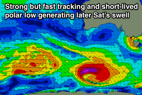
The source of this swell will be a deepening polar low to our south-west on Thursday, generating a fetch of gale to severe-gale W'ly winds before weakening rapidly Friday.
The fast eastward track of this system isn't ideal but the core wind speeds are good. We're probably looking at an easy 2ft+ wave later Saturday, peaking overnight and easing from 2ft Sunday morning.
Winds Saturday evening will likely be onshore and sea breezey with offshores Sunday but more on this Wednesday.

