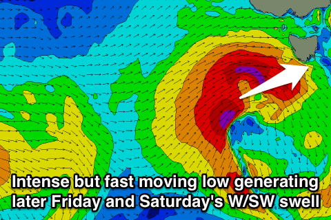
Short-lived swell later Friday, fading Saturday
Southern Tasmania Surf Forecast by Craig Brokensha (issued Wednesday 18th March)
Best Days: Saturday morning, Sunday morning, Monday from midday
Recap
A good pulse of strong SW groundswell filled in yesterday under favourable winds through the morning, reaching 2-3ft across Clifton. The swell was only short-lived though, with it backing off from 1-2ft today.
 This week and weekend (Mar 19 - 22)
Today's swell will ease into tomorrow leaving tiny waves across Clifton, but into Friday a strong pulse of W/SW groundswell is due into the late afternoon/evening.
As touched on last update, the frontal system generating this swell was positioned too far north to generate any real size across Clifton, with it due more into Saturday.
The latest updates have the re-intensification of the frontal system to our west now occurring at a more southern latitude and more within our swell window.
With this a fetch of severe-gale W/SW winds will be aimed through our western swell window on Thursday evening and early Friday (but the low will track quickly south-east), producing a strong but short-lived pulse of W/SW groundswell.
This swell should build Friday afternoon/evening, kicking to 2-3ft late across Clifton but with poor W/SW winds.
A peak is due overnight with a drop from 2-3ft due Saturday morning under much more favourable offshore N/NW winds ahead of afternoon sea breezes.
Sunday will be small and fading from 1ft to maybe 2ft as winds strengthen from the N/NE.
Monday onwards (Mar 23 onwards)
Into Monday a new long-range and very inconsistent W/SW groundswell is due to fill in, generated by an intense polar low firing up in our far swell window around the Heard Island region today.
A fetch of severe-gale W'ly winds will be produced before the low broadens but weakens into Thursday and Friday. From then the system will fade while pushing closer to us over the weekend.
The long-period fore-runnners from the swell are due to arrive later Sunday but the swell won't peak until Monday midday/afternoon to 2ft+ or so across Clifton. Winds should be good and offshore from the N'th ahead of a swing to the W/NW and late onshore change.
We'll have a closer look at this on Friday though.


Comments
H'mmmm
Nothing special Tim, and those long periods for Sunday evening have no size, generated so so far away. Monday will likely be similar to last Tuesday.