Good swell Tuesday with north-east winds
Southern Tasmania Surf Forecast by Craig Brokensha (issued Friday 13th March)
Best Days: Monday morning, Tuesday, Wednesday morning
Recap
A drop in swell yesterday back to 1-2ft and this morning, a new pulse of W/SW swell to 2ft didn't really eventuate with smaller 1-1.5ft sets seen.
 This weekend and next week (Mar 14 - 20)
Tiny waves are due into tomorrow morning, while a kick in swell Sunday has been upgraded with a front approaching from the west due to aim a fetch of strengthening SW winds through our swell window tomorrow.
This should kick up 2ft waves into Sunday but we're likely to see W/SW winds in the wake of an overnight change. If we're lucky we may see an early W'NW'ly across the South Arm before winds go back to the SW.
A drop in swell is then due Monday from 1-2ft under NW morning offshores and then SE sea breezes.
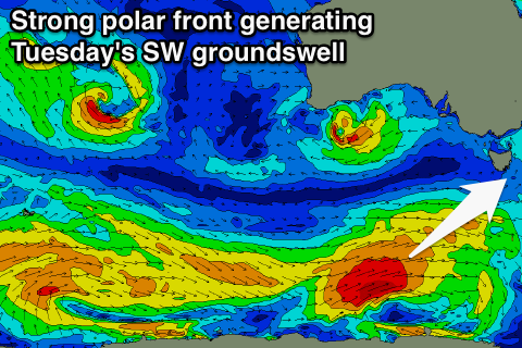
Our good increase in SW groundswell due Tuesday is still on track with a strong polar low expected to fire up in our swell window over the weekend, generating a fetch of gale to severe-gale W/SW winds perfectly towards us.
This should produce a good SW groundswell peaking through afternoon Tuesday to 2-3ft (smaller 2ft through the morning).
Winds are unfortunately looking funky and from the N/NE, favouring some spots over others.
A drop in size from 1-2ft is due Wednesday as winds hold from the N'th.
There's nothing major on the cards then until late in the week/weekend but this will be an acute W'ly swell generated by a vigorous mid-latitude low pushing in from the Bight, but we'll have a closer look at this on Monday. Have a great weekend!

