Fun waves over the coming period, best Tuesday
Southern Tasmania Surf Forecast by Craig Brokensha (issued Friday 6th March)
Best Days: Every day over the coming period
Recap
The swell came in stronger yesterday to 2-3ft across Clifton but winds were average through the morning before improving through the afternoon and swinging W/NW.
A stronger increase in size was seen today to 3-4ft but conditions are poor with strong onshore winds.
 This weekend and next week (Mar 7 - 13)
Today's swell is expected to drop into tomorrow leaving much smaller 2ft waves across Clifton with the possibility of the odd bigger one at dawn. N/NW tending W/NW winds should keep the coast clean all day so there's no rush if you're a beginner.
The swell is due to bottom out into Sunday but hold around 1-2ft for most of the day under NW tending variable winds.
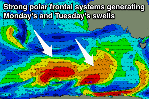
Into Monday and Tuesday we should see some good new W/SW groundswell filling in, generated by a couple of strong polar fronts firing up today and through the weekend.
An initial system today will be short-lived and a fair distance away to the south of WA.
This should produce a small increase in size that may be seen later Sunday but come in at 2ft through Monday morning.
A secondary system firing up right on the tail of the initial system will be longer-lived and push closer towards us, producing a better W/SW groundswell for Monday evening and more so Tuesday to 2-3ft across Clifton.
Conditions are looking great with a NW tending W'ly breeze Monday and then N/NW winds Tuesday morning that may give into a weak sea breeze.
A drop in size is due from Tuesday afternoon but weaker and broad frontal activity under the country through early next week should produce some smaller additional W/SW swells for later in the day Wednesday and more so Thursday and Friday to 2ft across Clifton.
Winds are due to remain favourable for the most part until Friday.
Longer term there's nothing too significant on the cards, but check back here on Monday for the latest on this. Have a great weekend!

