Plenty of swell, poor winds, better late Sunday
Southern Tasmania Surf Forecast by Craig Brokensha (issued Wednesday 4th March)
Best Days: Possibly late tomorrow, Saturday morning, later Sunday, Monday, Tuesday
Recap
Yesterday started near flat but a small kick in size was seen through the afternoon as poor morning winds shifted back offshore from the NW-W/NW. The swell backed off into this morning as we fell in betweens swells with tiny clean 1ft waves across Clifton.
The first pulse of better W/SW groundswell was due to arrive this afternoon and kick to the 3ft range by dark this evening, and the Cape Sorell readings are positive for a late pulse. Winds are also holding from the W/NW, so it'll be a worth a late look at the coast for a wave.
 This week and weekend (Mar 5 - 8)
This afternoon's kick in W/SW groundswell should ease back temporarily into tomorrow morning but another cold front projecting up into us through the morning should push 3-4ft into Clifton from early afternoon.
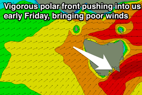
A final polar front pushing across us through Friday morning will likely keep 3-4ft sets hitting Clifton through the morning before easing back into the afternoon and further through Saturday.
Winds are now an issue both tomorrow and Friday with the timing of the frontal systems pushing across us not being favourable at all.
Tomorrow will likely see fresh to strong W/SW winds all day, but a late swing to the W/NW is a chance.
Friday will then see a SW change pushing through at dawn and poor S/SW winds into the afternoon.
Saturday will be clean with N/NW offshores but an easing 2ft of swell.
Sunday is expected to start out slow but a good new SW groundswell is due to build through the afternoon.
This swell will be generated by a strong polar low dipping in from the Indian Ocean, aiming a fetch of gale to severe-gale W'ly winds through our swell window before projecting north-east toward us Friday.
The SW groundswell should build through the afternoon, reaching 2-3ft by dark under fresh N/NW winds.
A drop in size is then due Monday with a possible less favourable W/SW swell following up into Tuesday. We'll have a closer look at this on Friday though.

