Good swell from Wednesday afternoon with workable winds
Southern Tasmania Surf Forecast by Craig Brokensha (issued Monday 2nd March)
Best Days: Tomorrow afternoon for small waves, Wednesday afternoon/evening, Thursday in protected spots for keen surfers, Friday, Saturday morning, Sunday morning
Recap
Tiny beginner waves on Saturday and then near flat conditions Sunday. A change through yesterday brought with it a kick in SW windswell today to 1-2ft as winds tended back offshore.
 This week (Mar 3 - 6)
This week and next week is looking to deliver much better waves across the region compared to the past couple.
A strengthening node of the Long Wave Trough moving in from the west and pushing across us Tuesday evening will bring with it a flurry of strong polar frontal acivity.
The first pulse of swell is due through tomorrow afternoon (the morning will start tiny) with a strengthening front pushing in from the west this evening aiming a fetch of strong W/SW winds through our western swell window.
Only a small pulse to 1-2ft is expected through the afternoon as winds hold from the W/NW all day.
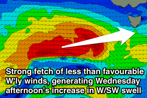
A much stronger frontal system pushing in under the country tomorrow will aim a fetch of W'ly gales through our western swell window before pushing across us Wednesday.
This should generate an acute W'ly swell that is expected to build Wednesday afternoon, from a small 1-2ft during the morning to the 3ft range by dark. Winds look to be favourable again for this swell and offshore from the NW tending W/NW, so a late look around the South Arm Wednesday may be fruitful.
The largest and best angled SW swell is due into Thursday and Friday as a weaker but more favourably aligned polar front pushes up across us Thursday, aiming a broad fetch of SW winds towards us.
This should see Clifton kick to 3-4ft Thursday afternoon before easing from a similar size Friday morning.
Winds Thursday are looking less than ideal though as the swell producing front pushes through with W/SW breezes, but Friday should see a W/NW breeze persisting most of the day as the swell eases.
This weekend onwards (Mar 7 onwards)
The swell should continue to ease into Saturday from 2ft+ or so under NW winds, while some new SW groundswell is due to fill in Sunday followed by some secondary and tertiary pulses Monday and Tuesday.
These swells will be generated by a couple of favourably aligned polar fronts skirting the polar shelf through the end of this week and weekend, generating good pulses of SW groundswell that look to be in the 3ft range. More on this Wednesday though.

