Fun S/SE swell tomorrow, stronger W/SW swell for the weekend
Southern Tasmania Surf Forecast by Craig Brokensha (issued Monday 19th January)
Best Days: Tuesday protected spots, Saturday, Sunday
Recap
Saturday morning started a little slow with a small clean 2ft of swell in protected locations, but a strong new W/SW groundswell filled in through the day as winds remained favourable and from the W/NW.
Sunday saw the most size with a larger SW groundswell filling in, coming in at 3-5ft across Clifton but conditions were poor with fresh to strong W/SW breezes, favouring super protected locations.
Today the swell eased back quite a bit with smaller 2-3ft sets with an early W/NW'ly before onshores kicked in mid-morning.
This week (Jan 20 - 23)
The SW swell should continue to ease into tomorrow, but a new S/SE swell is due to peak through the morning, generated on the backside of the frontal progression generating the weekend's swell. This should offer inconsistent 2-3ft sets across Clifton and surrounds during the morning under fresh to strong N/NE winds.
Come Wednesday morning the surf is due to bottom out, but a slight kick in new SW swell is due through the day, peaking into the evening. This swell will only likely come in at 1-2ft, generated today by a short-lived polar low to our south-west. Winds should be offshore Wednesday morning, but come the afternoon S/SE sea breezes will be in and blowing.
Thursday morning should be clean again but tiny on the backside of the swell.
Friday should also be tiny through the morning but a new acute W/SW swell is due into the afternoon ahead of some more significant swell over the weekend (outlined below).
 This weekend onwards (Jan 24 onwards)
Another strong node (peak) of the Long Wave Trough is forecast to move in from the west during the second half of this week before stalling while weakening across the south-east of the country.
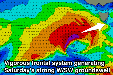
This should steer and intensify a series of vigorous polar fronts from the south-west of WA up towards SA and Vicco, through our western swell window.
An initial pulse of swell is due Friday, likely building to 2ft or so while a much stronger and better aligned frontal system pushing through our swell window Thursday and Friday should produce a moderate sized W/SW swell for Saturday coming in at 3ft+ across Clifton.
Winds look good for this swell as a secondary front approaching from the west steers winds back to the N/NW tending NE Saturday, creating clean conditions during the morning, while favouring other locations into the afternoon.
We'll review and confirm this on Wednesday though.
Beyond this we may see continued swell activity into early next week, but check back Wednesday for another update.

