Solid late increase in W/SW swell tomorrow, easing rapidly Wednesday
Southern Tasmania Forecast (issued Monday 27th October)
Best Days: Later tomorrow protected breaks (don't expect much at super protected breaks), Wednesday, Thursday afternoon, Friday
Recap
The weekend was average with a tiny onshore wave Saturday and then a small spike in swell to 1-1.5ft Sunday with N'ly tending NE winds.
Today the surf dropped away with tiny bumpy waves not worth worrying about across Clifton.
 This week (Oct 28 - 31)
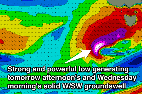
The moderate sized increase in W/SW swell expected through tomorrow afternoon and Wednesday talked about last week is still on track, but with a major upgrade.
Last week the models were moving around regarding one of the frontal systems moving in from the west deepening significantly, and this is now expected to be the case. A vigorous front that's currently to our west is due to project a fetch of severe-gale to storm-force W/SW winds through our western swell window before crossing us tomorrow.
This will generate an initial increase in short-range W/SW swell during the middle of the day tomorrow ahead of a larger spike in groundswell later in the day.
Clifton should build to the 3ft range early afternoon ahead of a larger kick in size towards 4-5ft+ dark. Unfortunately a peak in size is expected overnight, but Wednesday morning should still reveal 3-5ft sets across Clifton before easing rapidly back to 2ft+ during the afternoon.
Winds will be best for protected locations with a strong to gale-force W/NW tending W/SW winds tomorrow, while Wednesday looks excellent with NW tending W/NW winds.
The swell will likely be too west for super protected spots later tomorrow, so don't get your hopes up.
A secondary polar low firing up at a more favourable southerly latitude is due during the middle of the week, producing a secondary better SW groundswell for Thursday afternoon and Friday morning.
This swell should see clifton pulse back up to 4-5ft late in the day Thursday and ease from 3-4ft+ Friday morning. Winds should hold from the W/NW for most of Thursday with Friday looking excellent with N/NW tending variable breezes.
This weekend onwards (Nov 1 onwards)
One final pulse of decent SW groundswell is expected across the region through the weekend, as one final polar frontal system pushes up and into us during Saturday. The strength of this system doesn't look as strong as the previous and the alignment not as good but we should still see 3-4ft waves across Clifton into Sunday. Winds may be an issue though, so check back here on Wednesday for another update.

