Small W/SW swells through the week, larger swell for the weekend
Southern Tasmania Forecast (issued Monday 6th October)
Best Days: Wednesday afternoon, Thursday, Saturday, Sunday
Recap
Saturday was great with Friday's swell holding in at 3ft during the morning under offshores that tended more N'ly through the day, opening up plenty of options.
Yesterday was smaller, but a new SW groundswell arrived late in the day and this has peaked this morning to 2-3ft, a touch bigger than expected. The swell should of held most of the day with persistent N'ly winds.
This week (Oct 7 - 10)
Today's swell should ease off tomorrow, and we'll see a weak short-range W/SW swell coming in at 1ft to possibly 2ft generated by a strong frontal system pushing across us overnight.
Behind this though a better W/SW groundswell is on the cards for Wednesday afternoon to 2ft, ahead of a more SW groundswell to 2ft+ Thursday morning. This will be generated by two trailing polar fronts behind this evening's system pushing through today and tomorrow.
Winds should be good Wednesday and offshore from the N/NW tending W/NW, while Thursday should play out similarly.
Friday will be tiny and best for beginners.
This weekend onwards (Oct 11 onwards)
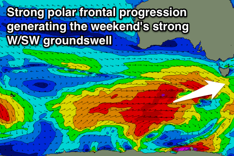
 Our better run of swell related to the Long Wave Trough moving in from the west later in the week is still on track with a strong polar frontal progression due to be steered through our swell window through the coming week.
This should generate a solid W/SW groundswell for Saturday afternoon and Sunday coming in the 3-5ft range at its peak. We'll have a closer look at this on Wednesday though.


Comments
Looks like a cracker weekend in Tassie.....any update???
Just updated: https://www.swellnet.com/reports/forecaster-notes/southern-tasmania/2014...