Fun easing swell Saturday, good at exposed spots Monday
Southern Tasmania Forecast (issued Friday 3rd October)
Best Days: Saturday, Monday at exposed spots
Recap
A mix of easing W/SW and building SW swell was seen yesterday morning with clean 2-3ft waves early. An onshore change moved through the day and the swell kicked strongly later in the day.
Today a peak in large S/SW groundswell was seen across the coast with 3-5ft waves at Clifton early, but we should of seen sets in the 6ft range through the day, with small waves in protected locations.
This weekend (Oct 4 - 5)
 Today's strong S/SW groundswell should of eased this afternoon and will drop considerably overnight, leaving fading 2-3ft waves across the coast tomorrow. Conditions should be great though with moderate NW tending variable winds.
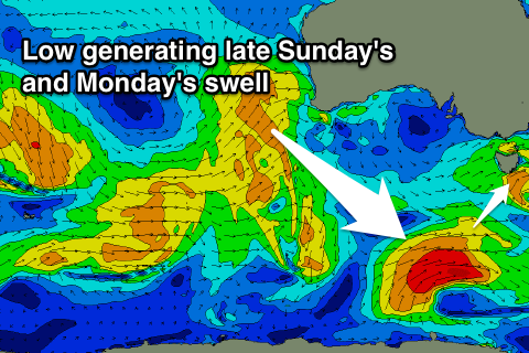
Sunday is expected to be tiny, but a new W/SW swell is due through the late afternoon to 2ft across Clifton before swinging more SW and holding to 2ft Monday.
Winds will be poor with a fresh W'ly tending W/SW breeze Sunday while Monday should offer better conditions at exposed spots with a strengthening N/NE'ly.
Tuesday onwards (Oct 6 onwards)
There's nothing too major on the cards for the rest of next week with small refracted W/SW swell to 1ft to maybe 2ft at times with favourable winds each morning besides Tuesday when an onshore change moves through.
Longer term the outlook is much more active from next weekend and into the following week as a strong node of Long Wave Trough moves in from the west later next week. We'll look at this again Monday so in the meantime, have a great weekend!

