Tiny ahead of a good W/SW swell Thursday/Friday
Southern Tasmania Forecast (issued Monday 8th September)
Best Days: Thursday, Friday, Saturday
Recap
A small increase in swell was seen Saturday to 1-2ft across Clifton, but a better pulse for Sunday came in a little under expectations early before filling in better through the afternoon. A drop back from 1-2ft has been seen this morning under favourable winds.
This week (Sep 7 - 12)
Give the surf a miss tomorrow and Wednesday as it will bottom out across the state, and a tiny and very acute W'ly swell due Wednesday morning probably won't offer much size above 1ft+ across Clifton. More exposed coasts may be worth a look though with an early N/NW breeze.
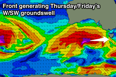
A much anticipated increase in strong W/SW groundswell for later in the week is still on track with a strong node of the Long Wave Trough pushing in from WA expected to steer a vigorous polar front nicely through our western swell window.
 A fetch of severe-gale to sub-storm-force W/SW winds will be projected towards us from south-west of WA, generating a strong swell that should arrive through Thursday, build through the day and reach 3-4ft across Clifton into the afternoon. A drop in size is then due from 3ft+ or so Friday morning, further down from 2ft+ into Saturday.
Winds will be good as the swell builds Thursday morning with a W/NW'ly but a shift to the W/SW into the afternoon will spoil the new swell. Friday should be clean all day with NW tending W/NW winds, with Saturday offering a persistent NW'ly.
This weekend onwards (Sep 13 onwards)
A small reinforcing SW groundswell is due Sunday off a much weaker trailing front on the back of the main swell generating system. This should keep 2ft sets hitting Clifton Sunday but winds look to go onshore with a front pushing across us.
Longer term a weak windswell is due Monday and Tuesday off the front pushing through Sunday, stalling and pushing up the East Coast. This will be along with onshore winds but we'll review this Wednesday.

