Plenty of swell, larger next week
Southern Tasmania Forecast (issued Wednesday 30th Jul)
Best Days: Thursday, Friday morning, early Saturday, Sunday, next week
Recap
The surf remained tiny through yesterday, but during the afternoon and evening a vigorous cold front passing under us produced a solid and on forecast 3-4ft of W'ly groundswell across Clifton this morning. A drop in size should have been seen this afternoon with the passing of the front.
This week and weekend (Jul 31 – Aug 3)
With the passing of the strong cold front today we'll see a drop in size into tomorrow morning but Clifton should still be in the 2ft range through the morning with the possibility of the odd bigger one.
Into the afternoon though a long-range W/SW groundswell is due, generated on the back side of the front responsible for today's swell but closer to the polar shelf.
This should build later in the day to an inconsistent 3ft and hold into early Friday.
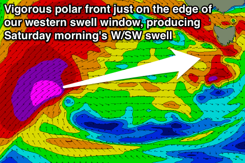
 A new acute W'ly groundswell is due into the late afternoon Friday though, generated by a polar front that's currently firing up south-southwest of WA, with it forecast to be projected up into SA under the effects of the Long Wave Trough. Wind speeds should reach the severe-gale range and while not ideally in our swell window, the sheer size of the open ocean swell should help us to see some good W'ly energy spreading out towards us.
This swell should fill in during the afternoon, pulsing to 3-4ft and then easing from an inconsistent and similar size Saturday morning. Unfortunately a strong onshore change is due Friday afternoon from the SW and this may hang into Saturday morning. There's a slim chance for an early W'ly but we'll review this Friday.
A steady drop in size is due from Saturday morning though with Sunday seeing a long-range and funky S/SE groundswell in the mix both coming in at 2ft under offshore NW winds.
Next Monday onwards (Aug 4 onwards)
Longer term is looking great with a large blocking high across Australia focussing the storm track further south towards the poles and within our swell window.
This should provide plenty of groundswell into next week, possibly becoming large but we'll look more closely at this on Friday.

