Tiny waves suited to exposed coasts
Southern Tasmania Forecast (issued Wednesday 23rd Jul)
Best Days: Thursday and Friday exposed spots, later Sunday, Monday
Recap
Monday's swell backed off to 1-2ft yesterday morning across Clifton under favourable winds, while today, even smaller 1-1.5ft waves have been seen.
This week and weekend (Jul 24 - 27)
More of the same surf is expected over the coming days and into the weekend with no major swell expected across the region. Clifton won't go flat but will only be worthwhile for beginners.
Winds will become more favourable for exposed locations tomorrow and Friday with a N/NW tending NE breeze on the former and N'ly tending NE winds on the later.
Into the weekend a weakening mid-latitude moving across us will bring funky winds that should be mostly variable in the morning before swinging SW into the afternoon Saturday.
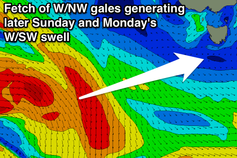
Sunday morning will remain tiny, but a new W/SW groundswell is now due to show later in the day and peak Monday morning.
 The source of this swell will be a vigorous and intense storm that's currently moving through the Southern Indian Ocean dipping away towards the polar shelf once passing south of WA tomorrow, generating a fetch of W/NW gales in our swell window.
While not ideal this should still produce an inconsistent and fun 2ft of swell later Sunday and Monday morning. Winds should be favourable and from the N/NW all day Sunday and from the NW Monday. Expect long waits between sets though.
Next Tuesday onwards (Jul 29 onwards)
The outlook for the middle of next week is looking up with an amplification of the Long Wave Trough pushing east across Australia. With this a flurry of frontal activity will initially be too north to majorly benefit us, but as the storms push further east we should see them moving more into our swell window, with at least a medium sized groundswell expected. Read more on this in Friday's update.

