Plenty of swell still to come with options opening up
South-east Queensland and Northern NSW Surf Forecast by Craig Brokensha (issued Friday August 2nd)
Best Days: Today, tomorrow, Sunday, Monday morning, Tuesday morning
Features of the Forecast (tl;dr)
- Large mix of mid-period E/SE-SE swell tomorrow (mod-large) Sun AM, easing into next week
- Mod-fresh W/SW-SW tending fresher S/SE-S winds tomorrow
- Lighter W/SW tending E/SE-SE winds Sun
- W/NW tending fresher N/NE winds Mon
- Mod-fresh W/SW-SW tending S/SE winds Tue
Recap
Our oversized pulses of S/SE groundswell still provided large 10ft+ bombs yesterday morning, easing slowly during the day and then back off from the 8ft range this morning.
The Goldy and Sunshine Coasts have ebbed and pulsed between 4-6ft on the magnets with 3-5ft sets still on offer today.
Conditions were lumpy and semi-clean during the mornings, wind affected into the afternoons and best towards southern corners.
This weekend and next week (Aug 3 - 9)
These notes will be brief today as Steve covers the Olympic surfing event.
Now that the significant and quite unprecedented low in the Tasman Sea has started to break down, we can expect the swell size and energy to continue easing into the weekend.

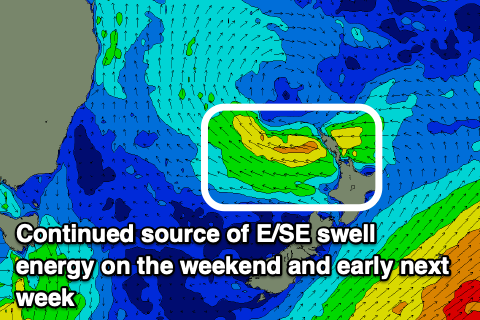
We should see large but easing sets from the SE tomorrow morning to 6ft across northern NSW, but there’ll also be some reinforcing, mid-period E/SE-SE energy from tomorrow through early next week as well.
This has been generated by a great and persistent fetch of E/SE winds off New Zealand’s North Island from yesterday through today, with it due to weaken slowly tomorrow.
The E/SE-SE energy should come in at 4-6ft tomorrow and Sunday morning across northern NSW, 3-4ft across the Gold Coast and northern ends of the Sunny Coast.
The downwards trend will be slow but consistent through early next week, likely from the 4ft range across northern NSW magnets Monday morning (smaller in Qld) and then 3ft max Tuesday.
Local winds look good tomorrow morning with a moderate to fresh W/SW-SW breeze, shifting S/SE-S into the afternoon, lighter W/SW tending E/SE-SE winds on Sunday.
A W/NW offshore will favour exposed beaches Monday morning in NSW, with fresh N/NE sea breezes developing, fresher W/SW-SW tending S/SE Tuesday as trough slides up the coast.
Longer term, swell wise there’s nothing to really talk about at all thanks to a zonal pattern setting up across the south of the country. More on this Monday and in the meantime get into the existing energy. Have a great weekend!


Comments
Fun morning on the Saphire Coast and a bit further south. Reckon its half the size now though, the late was 2-3' at a wave that was double overhead for the dawny
Banks have really copped a flogging here.
Storm bars on the beachies, points wide and deep.
Luckily that June solstice swell didn't flog them or that following E swell would have seen vastly diminished quality.
I expect our wave quality is going to be very much below average for the rest of winter and into spring.
I hear ya loud and clear Steve.
Sadly true. I hit Scomo's Noggin on the low tide yesterday, four foot and clean but terrible. One turn then a fat burger all the way to the beach. Even the loggers struggled
But coming right just around New Years, yes? :-)
Long range is suggesting a 180 switch from winter pattern to fully developed E'ly trade flow in the Coral Sea.
See how it looks in the update tomorrow.
Damn, that'll put good banks at a premium. I spoke to some chicks at lennox yesterday, said they'd looked byron to ballina and banks were pretty rubbish everywhere, same went for the spots I checked.
Broken point seems to have been gutted after having excellent sand for ages :(
Nice before that trough moves inland.
Could get very wet depending on that trough and infeed.
Yep
Please elaborate on the trough and infeed there Free fella 76 if you can
I had some deep gutter ,out to storm banks today.
Execellent waves , deep gutters and strong rips but sick waves.
Some of the regional points have benefited from the HUGE south swell that has just abated with the best sand in place ATM however more open beaches have huge inside gutters with wide (300m+) storm banks that break way out then fill up into the gutters! So a bit of Yin/Yang here on the Mid Nth Coast! Also not to keen chasing waves that quickly dissapate 300m offshore with the large amount of Apex predators around ATM!!!
Was just told to go to the Gold Coast points to get protection from the NNW winds ,9 local news
Also RIP Burtie. Was always fun guessing how cooked he'd be and which choice of poison. My favourites were 'on the piss from lunch, let's phone this shit in' and the classic 'smashed a couple nose-beers just before air'. Our group chat had a gentlemans $5 on it sometimes. Go well big rig.
GFS is pulling the trough away from the coast now. Looking like pumping E swell and good winds, if that's the case.
The big question Freeride, is whether you scored another snapper as this last swell backed off… still can’t believe the size of that thing you scored off the rocks previously.