Make the most of Thursday, as N'ly winds will ruin the rest of the forecast period
South-east Queensland and Northern NSW Surf Forecast by Ben Matson (issued Wednesday 19th September)
Best Days: Thurs: fun south swell and early light winds. Only small in SE Qld. Sat/Sun: building N'ly windswell, chance for pockets of N/NW winds opening up opportunities across a handful of coasts (don't get your hopes up though).
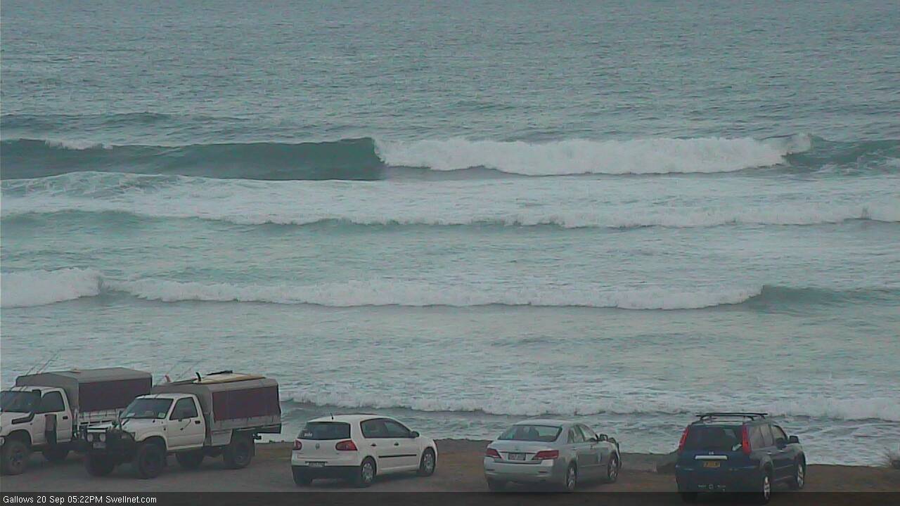
Recap: Easing S’ly swell on Tuesday was accompanied by strengthening N’ly winds so only protected northern corners saw anything worthwhile. Much of today has seen smaller residual south swell though the Mid North Coast has seen an afternoon pulse of fresh S’ly swell, pushing slightly above expectations with sets around 3-4ft (see image from Coffs Harbour below, a short time ago). It doesn’t seem to have pushed much further north than Coffs for the time being though (but will do overnight). Gusty S’ly winds this morning have eased and swung to a light E’ly breeze this afternoon.

New S'ly swell into Coffs Harbour this afternoon
This week (Sep 21 - Sep 22)
More southerly swell is expected through Thursday, and winds will be light and variable early. With an extended period of northerly winds ahead, Thursday morning will certainly be your best day to consider surfing in the next week or two.
Surf size will be biggest south of Byron where south facing beaches should maintain 3-4ft sets for much of the day, likely easing into the afternoon (more so in the south than in the north). Expect smaller surf at remaining beaches.
North of the border, this south swell won’t do much across most SE Qld points and beaches but exposed northern ends of the Gold Coast (and to a lesser degree, the Sunshine Coast) should see occasional 2ft+ sets.
Get in early as the light variable flow won’t persist much more than about late morning, with moderate NE breezes into the afternoon, becoming fresh in the south.
Friday looks really ordinary with strengthening N’ly winds and rapidly easing S’ly swells for much of the day.
The Mid North Coast may pick up a small afternoon flush of south swell, originating from a small secondary front wrapping around the transitioning Tasman Low midway between Tasmania and New Zealand today.
The models aren’t picking this up very well, and unfortunately the latest guidance has slightly tilted the fetch away from our region, but nevertheless I wouldn’t be surprised if we saw a few hours where south facing beaches (south of Coffs or maybe Yamba) picked up occasional 2-3ft sets just before dark. Away from these swell magnets, wave heights will be tiny and there won’t be much surf left across SE Qld either.
This weekend (Sep 23 - Sep 24)
We’ve got a poor weekend of surf ahead. The main culprit is a persistent N’ly breeze.
It’ll blow hard and strong both days, generating some local windswell though it’ll be short period, low quality stuff and those breaks picking up the most size will be wind affected. There’s a chance for a slight regional N/NW tweak in the wind direction across some coasts, which may allow several beaches to experience side-offshore winds for brief periods but in general it’s hard to get overly excited.
As for size, we’re looking at a slow increase through Saturday towards a peak early Sunday with 3ft+ sets at some NE swell magnets (expect much smaller surf at those locations not completely exposed to the north). Slightly smaller surf is expected across the Sunshine Coast owing to the short fetch length, and the broader size distribution will be patchy across most of Northern NSW (south of Byron) due to the poor fetch alignment.
Overall, this isn’t a swell event to work around but if you are desperate for a wave, there will be pockets of OK lefts running down some beaches. You’re just gonna have to sniff ‘em out.
Next week (Sep 25 onwards)
A broad mid latitude low will migrate into the Tasman Sea through Sunday, but it’ll be poorly aligned within all parts of our swell windows.
However, it will disrupt the northerly flow across the Mid North Coast Monday and Tuesday (only Tuesday across the Far North Coast and SE Qld region) which should allow for slightly cleaner conditions to coincide with easing N’ly windswell.
Unfortunately, these kinds of local windswells only have small windows where the wind eases and the surf persists - because of their close source - so it’s really not worthwhile recommending anything. But in short, there’ll be small weak waves around the exposed beaches if you’re desperate. Expect a burst of cold water too as these northerlies will probably trigger upwelling in many regions.
Elsewhere, a brief fetch of westerly gales exiting eastern Bass Strait sometime Monday should kick up a small south swell for Tuesday afternoon (Mid North Coast, into Wednesday in the Far North), but I can’t see much more than a weak, inconsistent 2ft across south swell magnets.
Gusty northerlies will then resume on Wednesday and Thursday - kicking up more local windswell - but ultimately without anything to get excited about.
Looking further ahead, and a series of deep transitional polar lows may provide some useful long period southerly groundswell later in the week and into next weekend, though nothing especially worthwhile is expected at this stage.
So in short - make the most of Thursday! See you Friday.


Comments
Ain't much happening across most of the Goldy, but D'Bah is picking up some nice peaks.
Coffs showing nice clean lines.. only one bloke out!