Easing N/NE windswell followed by S'ly swell
South-east Queensland and Northern NSW Surf Forecast by Craig Brokensha (issued Wednesday 13th September)
Best Days: Thursday morning north facing breaks, Friday and Saturday mornings south magnets, Monday morning south magnets
Recap
A bit of N/NE windswell across the region yesterday as the S/SE swell from Monday continued to ease. The morning was best across the northern NSW coast before sea breezes kicked in.
Today we've got a small mix of leftover N/NE and S/SE swells best left to desperate surfers and beginners.
This week and weekend (Sep 14 – 17)
These notes will be brief as Ben’s away today.
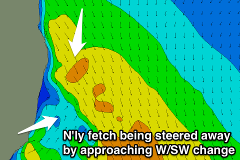
 A vigorous cold front that's currently pushing up across the south-east of the country is squeezing a high pressure system in the Coral Sea and we'll see winds strengthen again out of the N'th this afternoon and evening, producing another pulse of close-range N/NE windswell.
This swell will peak early tomorrow and ease quickly through the day as a W/SW change pushes through. The change is due to be in around the mid-north coast by dawn, while further north we should see winds swing offshore mid-morning.
We're likely looking at easing surf from 2-3ft at north facing beaches on the Gold Coast and northern NSW, smaller to the south and about 2ft with the earlier offshore change.
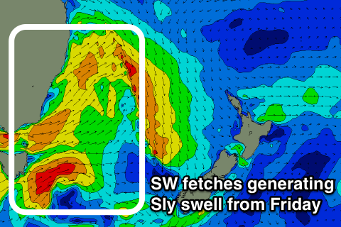
When the change kicks in we'll see a broad fetch of strong SW winds projected through our southern swell window, producing a late increase in S'ly swell, though Friday is the better time to get out and surf this swell.
We should see a peak Friday morning to the 3-4ft range across south swell magnets south of Byron, 2-3ft across northern ends of the Goldy and 1-2ft on the Sunny Coast.
A drop in size should be seen through the day and morning W/NW winds will give into afternoon E/NE-NE sea breezes.
Saturday morning will see a bit less size across south magnets across northern NSW, but a reinforcing acute S'ly groundswell will keep fun waves hitting the region. This will be generated by strong to gale-force W/SW winds exiting eastern Bass Strait Thursday afternoon and evening, with south magnets likely to persist around 3ft+ on the sets, easing later in the day.
 The Gold Coast will become smaller with small sets across known magnets. Conditions will be clean again through the morning before afternoon sea breezes kick in.
The next increase in swell will be seen through Sunday as another strong cold front pushes up the NSW coast early in the morning.
This will produce building levels of S'ly windswell, starting from a small base along with poor S'ly winds.
There'll also be some groundswell in the mix later in the day, produced by a very intense but small low pushing across Tasmania Friday evening. A quick burst of severe-gale to storm-force SW winds should produce a S'ly groundswell that will kick late Sunday and likely ease overnight and be gone by Monday.
A fun mid-period S'ly swell should still left in the mix from the fetch of SW winds moving up through the Tasman Sunday, coming in around 3-4ft south of Byron with a morning offshore wind. More on this Friday.


Comments
Always amazes me how much south swell North Straddie picks up compared to the rest of the East Coast (and specifically SEQld). It's gotta be 3-5ft on the outer bar right now.
Have a look how far east it is and you'll understand why.
I understand why Don ;)
My point being that it's sometimes the biggest spot on the east coast. Always hard to correlate when the Sunny Coast is often tiny to flat under similar swells.
Other than the obvious with South swells, does the offshore bathymetry play much of a part on the east coast as it does for somewhere like Nazare? Or is that all too deep/ far away?

Nazare is a completely different beast. Yes, offshore bathy plays a role however exposed northern ends will always pick up the majority of any energy glancing the coast.
Top marks for your emoji use, BTW.
Ben don't forget that although Point Lookout picks up heaps of swell, it hates a southerly swell and is almost unrideable. The place gets amazing waves in different conditions but for weeks at a time when the southerly swell and wind combo kicks in, you find something else to do.
It's be a different town (i.e. developed and popular) if it had a place that handled the predominant conditions.
And poor old Moreton copping the hate in that image haha!
Some places are saved by their flaws.
Indeed.. was just reporting from a met/ocean POV. Wasn't many surfable options around.
If you lived here you'd hate it too. Moreton's the bane of our existence lol.