Easing E'ly swells, building trade swells
South-east Queensland and Northern NSW Surf Forecast by Ben Matson (issued Monday 17th March)
Best Days: Tues for more inconsistent long range E'ly swell and light winds. Even though this swell will ease only slowly through the rest of the week, freshening SE winds and building SE swells will favour the Gold Coast through the second half of the week. Looks like a great weekend of trade swell and trade winds across the usual locations. And we could see this trade swell persisting for much of the following week too.
Recap: What a great run of waves and weather, eh? Friday’s SE swell eased through Saturday though the early morning saw initial 4-5ft sets at exposed beaches south of Byron Bay, and smaller 2-3ft surf across SE Qld. As these swells eased, we also saw a building long range E’ly groundswell through Saturday that’s maintained strong 4ft+ sets across SE Qld and Far Northern NSW through the weekend, and 3-4ft surf elsewhere. Also in the mix over the weekend was a secondary S/SE swell from a nondescript three way merger in the Tasman Sea late last week. This boosted the consistency through Sunday at many beaches and helped to peak up the straight E’ly groundswell. Today the S/SE swell eased back but the E’ly swell held in nicely, though it seems to have eased in consistency with some long breaks at times. Surface conditions have been great most days with mainly light winds and sea breezes.
This week (Apr 18 - 21)
Our current long range E’ly swell is expected to continue motoring along into Tuesday, though a gradual easing will probably occur into the afternoon. And set waves are likely to remain extremely inconsistent, so it’s likely that there will be long periods of tiny waves between sets.
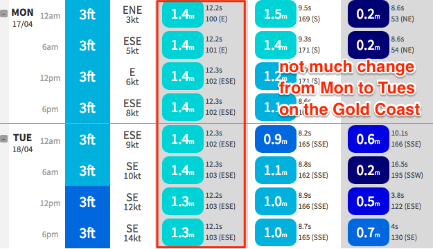
Model data maintains almost the same figures as per today (for example, 1.4m @ 12.3 seconds at the Gold Coast) so really, there’s no reason to change projected surf size - the biggest waves should push 3-4ft+ at exposed beaches across SE Qld, with marginally smaller surf south from about Ballina.

However, with this swell now the single source of energy in the water, it’d be quite possible to rock up and watch the surf for fifteen minutes and not see a single wave. So bear this in mind when choosing a populated lineup, as there won’t be many waves to go around.
Surf size will then slowly ease from this source for the rest of the week, however it’s expected to provide some kind of energy all the way through into the weekend.
Tuesday is looking great with mainly light winds and sea breeze in most areas, but overnight Tuesday a developing trade flow through the Coral Sea is expected to extend southwards and will influence local winds in SE Qld and Far Northern NSW from Wednesday onwards. Initially more southern regions (i.e. Mid North Coast) won’t be affected until later in the week (i.e. Thursday).
The good news is that this trade flow will kick up a more consistent, short range SE swell that will build from Wednesday into Thursday and Friday. It won’t have a lot of size but should kick up set waves around the 3ft mark across the Gold Coast by the end of the week, a little bigger across the Sunshine Coast but smaller south of Ballina.
With moderate to fresh SE winds on hand the points will be your best bet (though sheltered points like Noosa will initially be much smaller). Winds will be a little lighter across the Mid North Coast so there's a chance for periods of early SW winds here.
This weekend (Apr 22 - 23)
Although the long range E’ly swell will supply a small level of swell into the weekend, it really won’t be noticeable beneath the trade swell energy.
Winds are expected to reach a peak across the southern Coral Sea on Saturday which means a peak in local surf size around Sunday, with the Gold Coast likely to push 3-4ft at this time and slightly bigger surf across the Sunshine Coast. However, it’ll be smaller as you track south from Byron Bay (still 2ft, maybe 2-3ft across the Mid North Coast). Wave heights will probably be a little smaller on Saturday too.
It doesn’t looks like there’ll be much let up in the associated coastal SE breeze until Sunday and then it’ll only abate across the Mid North Coast.
So, the short version is that this building trade swell and accompany SE winds will continue to favour the outer Gold Coast points throughout the weekend.
Next week (Apr 24 onwards)
It looks like this pattern will remain entrenched across the Northern Tasman Sea and lower Coral Sea into the for some time, which suggests possibly another extended spell of small to medium sized trade swell fluctuating throughout most of next week.
Therefore, the long term surf prospects look great for the Gold Coast but also for most other parts of the coast - if we see a break in the synoptic trades against the coastal margin.


Comments
happy, very happy :)