Clean, easing swell to end the week
South East Queensland and Northern New South Wales Surf Forecast by Guy Dixon (issued Wednesday 8th June)
Best Days: Thursday, Friday and Saturday.
Recap:
Solid easterly energy and persistent offshore breezes have been providing excellent options in the past couple of days, with 6-8ft sets across northern NSW backing off to the 6ft range today. Southeast QLD has seen smaller options ranging from 3-5ft (smaller on the Sunshine Coast), but remaining generally workable.
This week (Thursday 9th - Friday 10th):
The northeasterly fetch which has been responsible for all of this great swell over the past few days has been moving east, with its alignment becoming progressively worse for the NSW coast.
In the coming days, the bulk of the easterly energy should dry up now that the main source of energy has lost alignment, however we are still set to see a few modest period pulses which should slow the easing trend throughout Thursday and Friday.
The surf should fade from around 4-5ft on Thursday along the coast of NSW, more so from the 3ft range along southeastern QLD. Another pulse on Friday morning will again maintain a small amount of energy, with sets easing from the 3-4ft range south of the border, more so from the 2-3ft range in QLD.
Thursday morning should remain clean across most coasts of NSW and southeastern QLD, losing quality as breezes swing northerly in the afternoon. Conditions should clean up once again on Friday as westerly breezes tend southwest throughout the afternoon.
This weekend (Saturday 11th - Sunday 12th):
Small hints of mid-range southerly energy should begin to show across south facing beaches of the Mid North Coast by Saturday morning generated by westerly fetches exiting Bass Strait, pushing further north throughout the day. Size wise, it only looks modest, providing options 2-3ft range with better energy to follow.
Before getting into that however, a southerly change looks to move up the coast of NSW on Sunday morning, tending southeasterly as a ridge becomes established over the eastern seaboard.
Short range, poor quality southerly energy is likely to build throughout Sunday across the south facing beaches of NSW to around 3-4ft, smaller north of the border.
Make the most of the first half of Saturday under a light/variable-offshore airflow preceding a light seabreeze. Sunday’s southerly change looks to limit options to protected southern corners/points where size will be lacking.
Next week (Monday 13th onward):
 Broad southwesterly fetches with core winds of 35-40kts should move south of Tasmania into our swell window late on Friday evening into Saturday morning.
A mix of mid-range energy and stronger southerly groundswell should push up the coast of NSW on Monday providing sets in the 3-4ft+ range across south facing beaches of NSW, providing only 2ft or so for the outer points of southeast QLD.
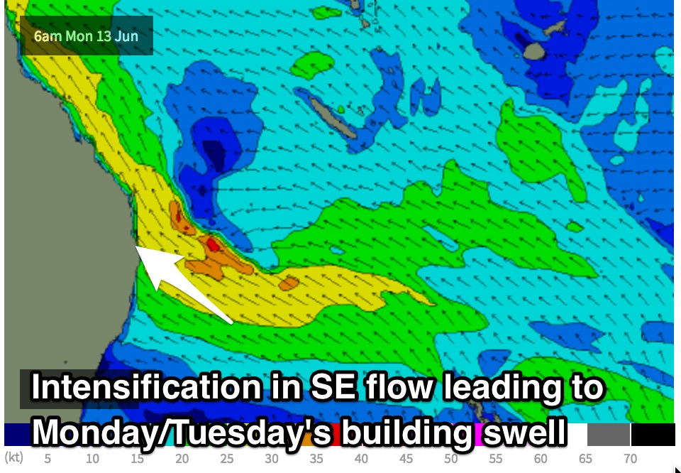
More substantial energy will build as a result of the aforementioned strengthening southeasterly airflow steered by a building ridge. This should add around 4-5ft of short range, low quality swell to the exposed beaches of southeast QLD, smaller across the points, building further on Tuesday as a dip develops within the broader flow.
Conditions are likely to be pretty ordinary early next week, as breezes swing from southeasterly on Monday thru to east/southeasterly by Tuesday. The points will be your best bet for an ordinary wave.
More detail on Friday.


Comments
Hmmmm, EC and Access G painting a very different picture to the GFS model output shown above Mon/Tues swell and yet no mention of the significant model divergence at this stage? Does that mean SN are leaning towards GFS coming to fruition?
Coming back to bank buster comments? Has it settled enough to gauge the condititions of the banks/sand?
Funny how silent it's been in these comments lately. Finally everyone STFU and went surfing for a change.
Lol give it a day or two Sprout
The surf is shithouse today. Big long walled close outs. I have checked from main beach to to the southern end. Waste of fuel
Yep banks look pretty fucked.
Seems to be an hour or so either side of the high tide has a bit of shape on the storm bank but most are a couple of turns before they mush out in the gutter and then close out in the shorey. That was yesterday with a bit of size.
More close outs outside today that just wash through to the shorey and do fuck all.
Handy as an ash tray on a motorbike.
sands all gone here. Every Point has been gutted.....those with a boulder rock bottom are breaking on that contour but every where else is deep.
Hard to say how long the rebuild will take: standard is between a month and 3 months, really depends on what happens next. A regime of small S'ly groundswells like last winter will get the sand moving back in and in filling the quickest. More short period E swell will keep it gouged out longer. Took over a year after the May 2009 storm, which had bigger surf but wasn't rideable.
Biggest rideable surf here since July 2001 on the Monday. Sunday was bigger but unrideable through the day at it's peak. It was really something.
Looking at the short to medium term charts I'd say you're looking at more E/SE swell than S'ly swells.
Low tide is certainly much much worse than mid tide from what I've seen. High tide will be crap given the stormbar/gutter/shorey scenario from what I've seen around the place.
yeah with local winds and short periods.
That won't rebuild banks.
you get a surf in out of this swell event Don?
No I didn't Steve. I was away (from the coast) all weekend and my current surf fitness levels are very low so I tried scouting around on Tuesday with little to no luck on banks and a paddle that wasn't 400m offshore!!!
Yeh, too many Board Meetings.
Im right too assume your live around lennox FR? Every time ive had the pleasure of having to come up your way i just linger between suffolk and lennox. What happens to the beach at suffolk/broken? Everytime ive been the swell comes in rather peaky. Just wondering if a swell can make a peaky beachie straight haha
anything with S in it refracts around the edge of the cocked hat rocks, making it peak up a bit. Combine that with any residual E swell and you get peaky beachbreaks.
I thought that was the case with S swells. But theres not much damage this big NE swell can do to that beach?
big NE swells punch straight in there.
Wow ! Epic and probably the Best , biggest most Perfect looking Waves I've seen on the East Coast. So many spots firing at solid 10-15 ft. Absolutely Perfect shape. If you couy get out without a ski. Beautiful to watch, yet frustrating missing out. By Monday/The it was still big but why couldn't the waves stay same shape when breaking off Shark Nets at Broady. Well done those who scored kinda easy access to these Insane bombs
Broken/Suffolk stretch is completely gouged out...some rocks exposed at Broken I've never seen before and looks to be deep water banks way further out than normal...all reforming into straight line close outs. May suit sub 3ft swells for shorey reforms on certain tides...other than that its a long way back for that stretch of beach.
Outside Tallows was pretty epic Monday though :-)
New storm banks have formed on the open beaches on the Mid nth Coast! Still pumpin thru wed/ thur! lovin this run of East swell as it's the perfect direction for heaps of setups here, wind has also lined up with w/nor/ w to west everyday! Yew!! & still 4to 5ft. Keep it comin Huey!!