Solid S'ly swell mid-week, remaining small north of the border
South East Queensland and Northern New South Wales Surf Forecast by Guy Dixon (issued Monday 23rd May)
Best Days: Wednesday and Thursday morning in NSW. Thursday morning for SE QLD.
Recap:
South-east Qld remained small across the weekend, with very small surf on Saturday bumping up marginally on Sunday but best suited to south facing beaches. With more exposure south of the border, a strong south swell building throughout Saturday, peaking Sunday with 4-5ft sets at exposed beaches, before easing back to the 3ft range today.
The mornings have offered the cleanest conditions under light offshore breezes, giving way to a light seabreeze each day.
This week (Tuesday 24th - Friday 27th):
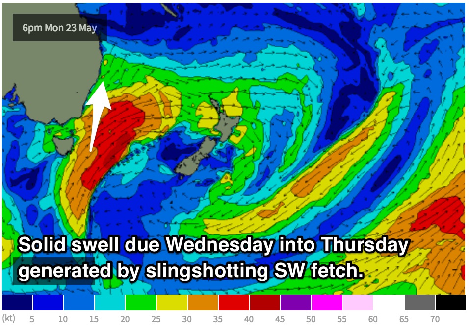
A westerly fetch is currently exiting Bass Strait, steered by a strong front and small scale cut-off low situated just to the southeast of Tasmania. With a few hours, these 30-35kt westerly breezes will tend more west/southwesterly and intensify to around 35-45kts while also broadening and becoming elongated.
As Monday night turns into Tuesday morning, this system is expected to stall, forcing the pressure gradient to tighten along the western quadrants of the low. As a result, an elongated fetch should become established over eastern and southern parts of the Tasman Sea.
Since Friday’s notes, this swell event has been downgraded slightly due to the system lacking the intensity that was once anticipated.
Nevertheless, mid range southerly energy off the initial fetches exiting Bass Strait should be just starting to build along southern parts of the Mid North Coast by Tuesday afternoon, building to around 3-4ft exposed back beaches on dark, further to the 4-5ft range under the cover of darkness.
Much more substantial groundswell is due on Wednesday as a result of south/southwesterly fetches on the back side of the low slingshotting up through the southern swell window in a captured motion.
 This energy should peak on Wednesday afternoon on the Mid North Coast, with sets in the 5-6ft range at south facing beaches, more so on Thursday further north. Once again due to the swell direction, less exposed beaches are likely to be significantly smaller, particularly across southeast QLD which may only pick up options in the 2ft range across the outer points (perhaps a touch more energy at the handful of south swell magnets).
Having said that, some exposed locations in Northern NSW may pick some strong sets in the 6-8ft range, especially at offshore reefs and bombies.
The Mid North Coast is due to see a southwesterly breezes first thing on Tuesday and Wednesday morning, more southerly along the North Coast and southeast QLD, tending light/variable onshore by the afternoon. Northwesterly breezes will dominate on Thursday morning, tending northerly and having an impact on wave quality across southeast QLD by the afternoon. The Mid North Coast is more likely to see a light variable airflow in the afternoon.
We are then likely to see a steady easing trend as the southern swell window takes a quick breather. Sets should ease fairly rapidly from the around 3-5ft range across the back beaches of NSW on Thursday (later further north), again with size limited across the less exposed spots.
It looks as though we will be in between swells on Friday, with left over energy providing options in the 2-3ft range at south facing beaches, becoming small across southeast QLD. Conditions should remain clean for the most part, under a broad scale west/northwesterly airflow, more northwesterly for southeast QLD.
Meanwhile however, a small low has the potential to develop off the coast of about Eden, intensifying quickly late on Thursday evening and into Friday morning. Small but intense fetches have the potential to steer 35-45kt winds up the South Coast of NSW, whipping up a moderate sized mid range swell for the weekend.
This weekend (Saturday 28th - Sunday 29th):
This swell should be moving up the Mid North Coast by Saturday morning, more so late morning further north, providing sets in the 2-3ft range across exposed back beaches, significantly smaller at less exposed beaches.
Unfortunately, the bad news continues for southeast QLD, without much size on the forecast. The direction of this swell is just too acute and the system too small and brief.
As this system deepens and migrates across the Tasman, the southwesterly fetches will become poorly aligned, allowing the initial swell to ease.
Weak southeasterly fetches on the southern quadrants of this low should then come into action however, providing energy later on the weekend. These fetches look modest throughout the duration of the system, although their slow moving, persistent nature should provide a small amount of workable energy on Sunday, with sets in the 2-3ft range maintained by a small southeasterly fetch anchored off the southern tip of New Zealand’s South Island.
On the plus side, conditions should remain clean virtually all day for all coasts on Saturday under a persistent westerly airflow, tending southwesterly and eventually onshore on Sunday.


Comments
"building to around 3-4ft exposed back beaches on dark"
Dumb question,... what are 'back beaches'? Beaches facing away from swell energy? So in this case north-facing?
Not a dumb question. Contrary to what it sounds, back beaches are the long stretches of exposed beach on the south side of a headland. Usually a township will reside on the northern, protected side of a headland or bay, probaby once to do with fishing vessels, with the back beach being over the hill or slightly removed.
This makes them more exposed to southerly swell energy and much larger on events such as this.
You couldn't have explained it better :-)
Thanks! Great to finally know!
yes, but the best S swell magnets, the ones that pick up the majority of the energy, the ones that people surf, in NENSW are not backbeaches.
Hey Free, are you in Fiji for this swell?
Care to enlighten us FR76?... presumably with a south swell the south facing beaches (which are what i am assuming Guy is referring to ?) are the most exposed ? Ocean bathymetry would have some influence also i imagine along with the type of bottom the swell is breaking upon ,reef .sand or shelf ?
I don't think you have to be a brain surgeon to know where FR is talking about if you know his local area.
And I'm pretty sure he's not about to broadcast it's name or location on the innerweb!!
If you know the Iluka/Yamba area it's pretty easy.
Yep, and thats why they've all been horribly packed and horribly vibed lately.
Heading to Noosa from this Thursday to Monday for a wedding. It's a long way from SA, you think it's worth packing a board?
If I'm completely honest, probably not. Tiny hints of S swell in the water only, virtually flat at the points. Worst case scenario you could hire?
Those open northern stretches sometimes surprise with the south swell they pick up. Can be decent while central and southern beaches on the coast are almost flat.
How's this longboarder styling across the inside section at Moffs this morning.
Styling?mmmm
All longboarders, please report to Moffats tomorrow morning. Cheers
Gonna be pumping on the Goldie tomorrow!
Going on 3 weeks now. Haven't had a spell like this since Spring. Magic day today though, crazy clear water, snorkel's getting a workout lately.
Been nice hey Sprout? Can't for the life of me work out why some folks in steamers. To each their own I guess.
Tomorrow morn maybe few waves about , south swell magnets yada yada
Just magic clean weather. Steamers!? The water is still warm and with no wind, maybe they're from 1770 haha.
Let's hope so, an hour before full tide had a (very slow but who isn't desperate up here) few today if you knew where to look.