Easing Sat, rebuilding from the south Sun, then sneaky E/NE and SE swells next week
South East Queensland and Northern New South Wales Surf Forecast by Ben Matson (issued Friday 8th January)
Best Days: SE Qld: Make the most of the weekend as the forecast for next week looks a little tricky; bar a flukey E/NE swell for Tues. Northern NSW: great waves most days, becoming affected by northerly winds Tues/Wed though.
Recap: Exhausting stuff, is all of this great surf. Both Thursday and Friday produced great, sizeable waves across Northern NSW though the swell direction went a little more towards the S/SE, and winds did become fresh and gusty at times. Surf size was much smaller in SE Qld but generally in the 3ft mark at outer points and open beaches, and early light winds created smooth conditions. We’re now on the backside of the primary S/SE swell that originated from the ECL off the central NSW coast.

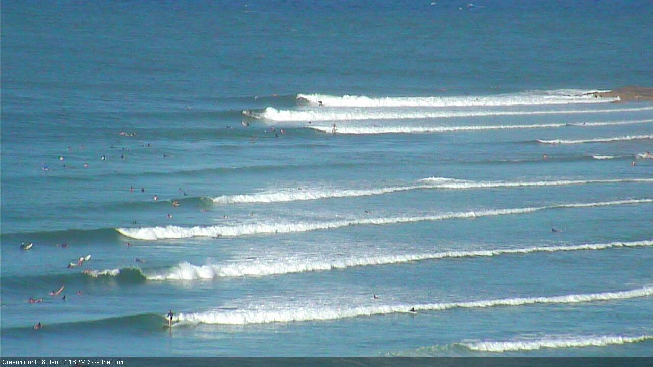
Still some fun waves at the Superbank late Friday afternoon
This weekend (January 9th - 10th)
A pretty easy description for the weekend - steadily easing all day Saturday, then up strongly on Sunday from the south, but only favouring Northern NSW, specifically south facing beaches.
Northern NSW: The current S/SE swell is on the way out though exposed south facing beaches in Northern NSW should still see early 3ft to maybe 5ft sets, before wave heights throttle back steadily during the day. Surf size will be smaller at most other locations (2-3ft+, also easing), being a mix of swells from the S/SE and some leftover E’ly swell too. Protected locations will be with very small as the swell trend backs off. Expect smaller surf through the afternoon.
Conditions are looking pretty good in general with early light SW winds tending S’ly then moderate SE throughout the day, so the semi-exposed points should have some fun waves throughout the morning - let’s hope the early high tide doesn’t swallow up too much of the energy.
On Sunday, a new long period S’ly groundswell is expected push up the coast. In fact, the Mid North Coast may see the leading edge of this swell push through later Saturday. South facing beaches will pick up the biggest waves with solid 4-5ft+ sets at times, but the acute southerly direction will significantly limit size across remaining beaches (2-3ft) with very small waves inside sheltered southern corners and super protected points - mainly sourced from residual E’ly swell from the South Pacific. Again, early light SW winds will swing into a SE sea breeze so aim for the morning for the best waves.
SE Qld: Make the most of Saturday as it’s expected to see the most size across the broader region. The current S/SE swell will ease steadily over the weekend though we should see small persistent - if somewhat inconsistent - E’ly swell across open beaches both days.
Most coasts should see an undercurrent of peaky surf in the 2ft range, with Saturday morning offering a few bigger waves, mainly at south swell magnets. Early light SW winds should offer the best conditions with moderate S’ly tending SE breezes expected after lunch confining the best waves to the outer points.
Sunday’s new S’ly groundswell mentioned above should light up south swell magnets with occasional 3ft+ sets but most Gold Coast and Sunshine Coast beaches and points will probably dip out, offering peaky 1-2ft surf. So, if you’re looking to get wet Sunday, aim for an exposed south facing beach and hit it early whilst winds are light.
Next week (January 11th onwards)
Sunday’s southerly swell will ease through Monday, with plenty of great waves expected across Northern NSW that should still be picking up some healthy sets at south facing beaches, in the 3-4ft+ range at first light (smaller throughout the day). Wave heights won’t be anywhere near as big at remaining locations and north of the border we’re looking at a continuation of small residual E’ly in and around the 2ft range at exposed beaches. The models have about a metre of swell at just over nine seconds across SE Qld, which usually translates to slightly higher surf but I'm skeptical that there'll be that much easterly energy to start the working week.
TC Ula is still meandering between Fiji and southern Vanuatu, tucked just inside the swell shadow of New Caledonia. It’s expected to re-emerge later Sunday, however the latest model guidance now tracks TC Ula - weakening by this time - reasonably quickly to the S/SE from Monday through the middle of the week.
By my reckoning, I think we’ll see a brief window of swell production before TC Ula’s southerly track becomes too fast across the Great Circle paths to benefit any major new swell. This new pulse is expected to arrive on Tuesday however it’s very hard to have much confidence in the surf potential, because despite TC Ula still likely to be close to cyclone strength at this time (Cat 1), the fetch length will be very short and unlike its earlier incarnation, there will be no supporting ridge to the south.
I think there’s a reasonable chance for some rogue 2-3ft+ sets up and down the coast - arriving Tuesday morning across the Gold, Sunshine and Far Northern NSW coast, but with a lag across the Mid North Coast - but in general there’s likely to be very long breaks between sets. Keep your expectations low, as solitary cyclones like this have a greater than average chance of underperforming.
Also compounding the issue on Tuesday is a freshening northerly breeze. It’ll be strongest in the south and lightest in SE Qld, but this will certainly cause some issues throughout the day. So aim for an early surf in the northern locations, and let’s hope the swell kicks across the Mid North Coast before the wind picks up.
There is one other interesting swell source for the long term. Over the weekend, a series of vigorous fronts will track across southern New Zealand, associated with a Long Wave Trough. A deep polar low just off the Ice Shelf is expected to remain stationary (S/SE of NZ) and as the last fronts push through, it’s expected to intensify and aim a long belt of gale to storm force winds up through a rare long range SE swell window, reaching peak intensity on Sunday afternoon.
This swell is expected to reach southern NSW on Wednesday and should be in the water across Northern NSW (and exposed south facing beaches in SE Qld) on Thursday. I’d still like to assess the satellite winds (on Monday) before confirming surf size estimations, but at this early stage we could be looking at fun 3-4ft waves across exposed spots in Northern NSW, albeit with very long breaks between sets.
Have a great weekend, see you Monday!


Comments
What a week, eh? I am buggered.
I had to turn my back on it today.....just too shagged.
I spent yesterday morning mostly going over the falls. My arms had given up.
Thought I could get away without surfing today, checked the usual suspects and the sweep was really bad and most spots weren't anywhere near the quality of previous days. Got to the office further north and it was pumping out front so had no choice but to paddle out. Scored a couple of great waves but couldn't last the distance as I was all paddled out.
My heart pumps piss having your office where it is Ben!!! ;)
just snagged late one at the Point. Still fucking solid with heaps of water moving. About a twenty kilo spanish mackerel greyhounded chasing bait right beside me and that seemed a good time to come in.
I think you undercalled this ECL swell Ben. It's pretty hefty here.
Yeah it was a little bigger; forecast was 4-6ft and it was close to that on the Tweed so I would have expected easy 6ft+ south from Byron given what I saw here.
Hey Ben, A big thanks for the forecasting your putting out for us all. Top job. Yeah regarding fish...heaps and heaps of mullet down this way early this morn at fun point all by myself.
Thanks mate. Been a lot of challenging work but very enjoyable watching the evolution of each of these swells.
Had some real fun waves over the last few weeks, lots of paddling....didn't like it at the time, but it has been great for building up my fitness/stamina.
Mooloolaba buoy showing something odd before lunch?
North Moreton Bay buoy showing something similar too.
You've had your fill... Just as well.... Looking pretty lame next week..... Nothing at all.... The only hope I see long term wise is that deep polar low mentioned, and a wet season burst "trying" to fire up across the top end post 17th/18th.... Worth watching, with 1-possible trough link through S.A, and 2- potential small dip south of New Cal..
Back to the small stuff on the Sunny Coast, but conditions are nice.
Holy smokes that south swell was pumping on the Tweed this morning. Easy 3-4ft, some bigger sets, light offshore winds.
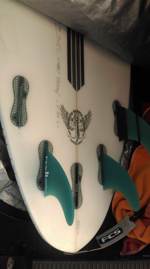
Indeed it was on the pump on the tweed this morn, I tried to get a quick one in before work only to open my board bag and find this.
So no surf before work for me. As an aside does anyone have any tips for removing the base of an FCS2 fin from the fin box?
Small drill bit, small screw, and some pliers..?
Beat me to it Welly,agree couple of screws and a loop of wire fastened to both screws and a screwdriver or piece of rod under the wire....and a yank upwards ?
Hat's off to the glasser. He put them in well. Most off the shelf boards would have popped the plug.
As Udo pointed out elsewhere too, STC Ula has strengthened to Cat 4 and is expected to clip southern New Cal. Haven't had a look at the charts yet (to see if the forecast should be upgraded) but will do so later.
Anything to report on TC Ula and what it means for NSW north coast Ben?
Here comes those 1 foot, NE windy swells creeping in. Qld's miracle summer might be over for now
No major changes to the swell potential from TC Ula at this stage. Although it's much stronger than forecast on Friday (Cat 4!), it's expected to track rapidly across the Great Circle paths and thus has had/will have only a limited window of swell production. And the fetch length is still very short too which further impedes swell potential.
The leading edge of this swell should push through Tuesday morning with a steady increase all day, in fact we may not see the peak of this swell until early Wednesday morning however I'd be surprised if it was much bigger than the upper end of what was originally forecast (2-3ft+). Perhaps some 4ft sets at exposed spots across SE Qld and Far Northern NSW late Tuesday and Wednesday, with a delay on this peak across more southern locations. But it'll be very inconsistent.
Gonna be another tough call for you Ben given she's tucked up there behind New Cal.
Indeed.
Probably gonna kick myself later this week (or next week) once I look back at these photos, but couldn't bring myself to paddle out this morning. Still holding around the 3ft mark and clean with light offshore winds.
Anyone willing to go out on a limb re' possible super long distance east swell??? 17/19th charts have a pretty impressive system forecast out near 160w 25s...
Definitely something brewing up out there but looks to lack a decent supporting ridge until it gets closer to the North Island. One to watch, for sure.
Indeed, FR..... Possible active sea state too.....
Sheepdog. Just let me know when i can bring out the beast call.