Small fun surf over the weekend
South East Queensland and Northern New South Wales Surf Forecast by Guy Dixon (issued Wednesday 30th September)
Best Days: Saturday morning and Monday morning.
Recap:
Virtually all coasts across northern NSW and southeast QLD offered clean conditions early under light offshore breezes and small but workable surf. A northeasterly seabreeze increased in the afternoon and had an impact on the quality surf, creating a fair amount of chop at virtually all locations with the exception of protected northern corners.
The remnants of a southeasterly swell have continued to fade today. We are left with 1ft left overs under a northeasterly seabreeze. Not much energy and not much shape.
This week (Thursday 1st - Friday 2nd):
The rest of the week is looking to remain fairly dormant with an apparent lack of swell generating systems passing through the swell window. The only hint of surf will be picked up by exposed south facing beaches around Port Macquarie and Coffs Harbour generated by a small southerly fetch off the east coast of Tasmania this morning.
The should build to an inconsistent 2ft on Friday afternoon, with virtually no energy elsewhere. A light southeasterly breeze will be dominating over the Mid-North Coast and Northern Rivers by the afternoon, so conditions aren’t looking that flash despite a small increase in swell.
This weekend (Saturday 3rd - Sunday 4th):
A small easterly trade fetch has been developing just south of New Caledonia throughout today. This small and virtually stationary area of 15-25kts winds is pretty weak and insignificant, however it is likely to persist for another 24 hours or so.
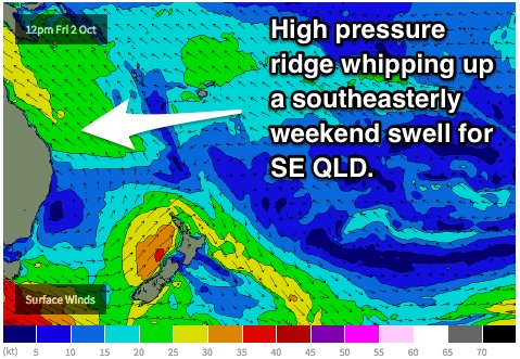
 A ridge looks to dominate over the eastern seaboard from late on Friday setting up a southeasterly airflow over the QLD coast persisting into next week. This will be a much more promising source of southeasterly swell for locations north of the border.
These two swell sources combined will provide a mix of swell resulting in the surf building to the 2ft range for southeast Queensland on Saturday. The Sunshine Coast has the potential to be slightly larger at exposed beaches (maybe 2-3ft) as the south-easterly fetch has a little more length for this region, however wave heights will be smaller across the points. Winds look to prevail from the southwest in the early morning allowing for clean conditions before swinging through to the southeast.
Northern NSW will miss out on most of the energy from these trade flows as the main fetch will be situated too far north. Instead, this part of the world will rely on energy generated from the southern Ocean/Tasman Sea which will heavily favour south facing beaches.
A strong frontal progression is still on track to pass to the south of Tasmania throughout Thursday steering a poorly aligned west/southwesterly fetch of with core winds of around 45-50kts. In Monday’s notes, we identified the most important part of the system being the southerly trailing fetch on the southwestern quadrant. The latest model run has really played down this fetch which mean Saturday’s swell isn’t looking as strong.
The surf should still build to around 2-3ft at exposed south facing beaches late in the day however, but we will be largely relying on side-band energy for the most size. Remaining beaches will be significantly smaller. Light offshore are likely early preceding a light afternoon seabreeze in the early afternoon.
Sunday will see these swells fade preceding the next pulse.
Next week (Monday 5th onward):
A second system which is due to move south of the southern Tasman throughout Saturday has changed quite a lot since the last forecast.
As the primary low approaches the swell window, a west/southwesterly fetch will slingshot towards southern parts of Tasmania, intensifying a lot later in the swell window than previous model runs. The core fetch of 50-60kt winds is still terribly aligned, however models are still suggesting a healthy trailing southerly fetch to develop.
The back side of the low is likely to be the main swell generator as it moves through the eastern periphery of the swell window.
All factors taken into consideration, northern NSW should see the long period swell front fill in late Sunday into Monday, however the real increase in size will be felt late on Monday into Tuesday as the bulk of the swell fills in. Exposed south facing locations should bump up to the 2-3ft range under by the afternoon. Remaining beaches will probably see little to no size from this pulse. All coasts should see clean conditions under light offshore breezes early, before a northeasterly seabreeze increases in the afternoon.
The blocking pattern which allowed for last week’s slow moving weather systems has now broken down and we are in a more zonal pattern.
In the coming week, frontal activity will remain fairly active, however any fronts will pass through the swell window rapidly which leaves very little time for significant swell generation. We will have to rely on small pulses of short range southerly energy in the long term.


Comments
Guy/Ben any idea whether we are still looking at the same forecast for this weekend on the Goldy??
We'll have an update around 5pm.
Cool Thanks have a great weekend