Fading swell with only subtle pulses on the way
South East Queensland and Northern New South Wales Surf Forecast by Guy Dixon (issued Friday September 25th)
Best Days: Sat/Sun: small waves in SE Qld, and at the semi-exposed points in Northern NSW. Mon: small/mod SE swell with early light offshore winds, easing Tues.
Recap:
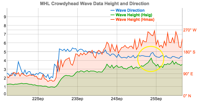
 Northern NSW: A large and long awaited swell impacted the Northern NSW coast on Thursday with surf in the 5-6ft range across exposed south facing beaches. The peak of this swell arrived later than expected, peaking in the late evening under the cover of darkness (as per data from the Crowdy Head buoy, see to the right). Protected southern corners offered the only workable options as a strong south/southwesterly flow rendered remaining beaches a write-off. Generally speaking the surf was a similar size, or a touch bigger today than what it was by nightfall yesterday across much of northern NSW. Fresh/strong south/southwesterly winds are limiting options once again to the more protected bays and coves where the surf is smaller but much cleaner.
SE Qld: North of the border, the surf built to around 2-3ft across the outer points on Thursday, with a few 3ft+ sets showing their face occasionally today, but many beaches were smaller than this and overall this swell event has fallen short of forecast expectations. The acute southerly direction and modest swell periods all combined to limit refraction into the outer points of the Gold Coast. Exposed locations further north and south have since offered more size, but are wind affected at times under a gusty southerly breeze.
This weekend (Saturday 26th – Sunday 27th):
A Tasman low has been dominating our charts for the past few days and has been the main contributor of this strong swell. There haven’t been any significant other swell generating systems during this time, so the size will diminish steadily throughout the coming days.
The surf will fade to the 4-5ft range throughout Saturday across the exposed coasts of northern NSW, dwindling as the day progresses. Most open beaches in SE Queensland will ease back to an inconsistent 2ft, but there should be a few bigger waves at the outer points from time to time and it will be bigger again at exposed south facing beaches.
Although lighter than what we’ve seen in the past few days, fresh southerly component winds will hug the coast, limiting options to the protected southern corners. If the last few days are anything to go by, you’ll be forced to sacrifice a lot of size for the cleanest wave. Protection from the wind will be particularly important for southeast QLD as the airstream tends south/southeasterly in the afternoon.
By Sunday afternoon, the surf will have eased back to the 1-2ft range north of the border. Winds will ease steadily throughout the day, tending light southeasterly in the afternoon across all coasts. Northern NSW should still see 3-4ft leftovers at most open beaches but fresh southerly winds are again expected as a ridge firms up against the coast, but a moderate southwesterly breeze is possible early morning, which will hopefully allow for clean and workable surf at protected locations for a period.
The next swell generating system is likely to fire up this afternoon in the form of a small scale low sitting off the southern tip of New Zealand. The 30-35kt southeasterly fetch generated by this system will be working on an active sea-state allowing for faster and more efficient swell generation for around 18-24 hours. In the later stages of its life-cycle, this little system will extend a fetch over further into central/southern parts of the Tasman creating a small captured fetch. Although this swell is expected to peak overnight Sunday and into Monday morning, we should start to see a small upwards trend later Sunday afternoon (mainly on the Mid North Coast, with a later arrival further north), with set waves pushing 3-4ft+ at open beaches. It's just a shame that local winds aren't looking too flash as this swell builds.
Next week (Monday 28th – Friday 2nd):
This new SE swell is expected to be best aimed towards Southern NSW, so we're looking at smaller waves further north. Most open south facing beaches on the North Coast should see 3-4ft surf on Monday morning, but it'll be smaller north of Byron Bay, and certainly up into SE Qld with inconsistent 2ft surf. The Northern Rivers should be under a southwesterly breeze early, tending light east/southeasterly by the afternoon. Queensland coasts will be under light westerly winds for the best part of the day, with a light onshore breeze picking up late.
By this stage, the aforementioned low off the New Zealand’s South Island will have done a funny tour of the Tasman on Saturday ('retrograding', which is an unusual westward track) before fizzling out on Sunday and not really providing any other noteworthy swell.
A second small low is expected to develop off the Far South Coast on Tuesday as a trough pushes in from the west, which should generate a small southerly fetch of 25-35kt winds over southern parts of the Tasman as a third low pressure centre forms east of Tasmania (assuming the GFS scenario, EC is more delayed). However this is inside a very acute part of our southern swell window so confidence is not yet high that we'll see anything decent away from a handful of super south swell magnets in Northern NSW (around Wednesday).
So, expect smaller SE swells to pad out the middle of the week. The only other potential (besidess a small developing trade flow south of Fiji around Tuesday) will be around some coastal troughiness that's expected to linger across much of eastern NSW through Wednesday and Thursday and could be the source of a brand new close range system for the end of the week, and therefore next weekend. More on this in Monday's update.


Comments
Plenty of small SE lines across the Goldy.
Plenty of linez at Moffs too. Shame about the arvo nor'easter.
Here comes the stalling Tasman highs.