Small average weekend; good potential for later next week and beyond
South East Queensland and Northern New South Wales Surf Forecast by Ben Matson (issued Friday 11th September)
Best Days: Sat/Sun: small peaky tradeswell (SE Qld) and small inconsistent S'ly swell (Northern NSW) with early offshore winds. Mon: small trade swell in SE Qld. Thurs onwards: couple of swell sources looming.
Recap: Reasonably solid S’ly swells were generally wind affected in Northern NSW on Thursday as a ridge developed across the coast. These swells have eased in size today with similar winds. Unfortunately, surf size remained very small in SE Qld on Thursday due to the southerly direction, although we’ve seen a small building short range SE swell across the region today, thanks to a building ridge through the Coral Sea. The Gold Coast is around 2ft at exposed locations but the Sunny Coast is starting to see a few bigger 2-3ft sets.
This weekend (Sep 12 - 13)
On the balance, not a great weekend of waves. But there’ll be options around. Let’s break it up into regions: first up, SE Qld.
The ridge across the Coral Sea is positioned mainly north of our swell window, so most of the swell it's generating is pushing away from our coast. Additionally, this ridge is expected to slowly retreat northwards (i.e. weaken within our swell window) on Saturday before slightly restrengthening later Sunday - but at a distance from the mainland (so any renewal in energy probably wouldn’t arrive until Monday).
As such, we can expect the biggest waves on Saturday morning with slightly smaller surf levelling throughout the afternoon and into Sunday. At its peak, the Sunny Coast should see set waves around the 3ft mark at exposed beaches, with 2ft+ surf across the Gold Coast, and proected spots will be much smaller. The swell won’t be strong nor very well defined, and early light SW winds are expected to shift SE during the daytime. Keep your expectations low and you might pick up a few fun beachies.
In Northern NSW, wave heights from this trade source will be smaller with increasing distance from the border (don’t expect much south of Ballina or maybe Yamba).
In addition, we’ll see easing S’ly swell from today but a small new S’ly swell build during Saturday, originating from a series of strong but poorly-aligned fronts in the Southern Ocean on Wednesday and Thursday. There may be a delay on this new south swell early morning but it’s expected to build throughout Saturday afternoon and hold intermittently into Sunday, with 2ft+ sets at south facing beaches (and smaller surf elsewhere).
Fortunately, winds look generally much better south of Byron Bay with mainly light variable winds in the morning and and moderate sea breezes in the afternoons. So again, keep your expectations low and you may do OK.
Next week (Sep 14 onwards)
A deep but poorly aligned front/low combo will pass south of Tasmania tonight, and is expected to generate a fresh south swell for the start of next week. However despite the impressive (modelled) core wind speeds I’m really unimpressed by the storm track and its fast eastwards trajectory, so I’ve slightly downgraded the swell potential for Monday.
I think most south facing beaches in Northern NSW will be lucky to see inconsistent 1-2ft waves from this source, with a chance for some bigger sets in the Hunter. Winds are expected to slowly freshen from the north during the day but it’ll probably be light NW early.
In SE Qld, the trade swell will probably hum along in the 2ft range on the Gold Coast on Monday with larger 2-3ft sets on the Sunny Coast, and similar winds as per the weekend are likely (variable early, sea breeze in the afternoon). This energy is then expected to ease slowly through the middle of the week. Northerly winds are likely to impact the SE Qld region on Tuesday ahead of a shallow S’ly change some time Wednesday. No immediate swell potential currently sits behind this change though.
Beyond this, we have a few sources to keep a watch on for next week. Model guidance has the leftovers of Wednesday's S’ly change lingering in the Central Tasman Sea in an unstable troughy configuration that could result in a solid mid-range east swell somewhere across the East Coast later in the week, through next weekend.
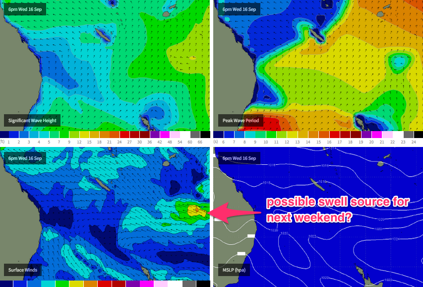
A broader tropical system is also expected to develop SE of Fiji around Wednesday (see chart below), and meander throughout the South Pacific for some time. Confidence is not yet high on its strength, position or track but this is certainly a possible source of long range E/NE swell later in the forecast period.
And lastly, a series of vigorous fronts through the Southern Ocean all have potential to supply small long period S’ly energy for Northern NSW through the longer term period - nothing worth working around but probably enough to keep exposed beaches from becoming flat (in the absence of any other swell events, which currently looks unlikely).
Have a great weekend, see you Monday.


Comments
Gee not sure that current forecast fetch out in the tropical South Pacific is gonna produce too much swell for SE QLD? Inconsistent 1-2ft at best.
Just one to keep a watch on Don, that's all. Models are a little scatty for next week, anything is possible.