Poor run of surf from tomorrow through early-mid next week

South Australian forecast by Craig Brokensha (issued Friday March 28th)
Best Days: Wednesday morning South Coast, Friday morning South Coast
Features of the Forecast (tl;dr)
- Strong S tending S/SE winds tomorrow with a late increase in windswell, peaking Sunday, easing Mon
- Moderate sized mid-period S/SW swell Sun with strong S/SE winds
- Easing S/SE windswell Mon with a stronger S/SW groundswell arriving later, peaking Tue
- Fresh SE winds Mon, easing and tending more E-E/NE on Tue AM (S/SE PM)
- Easing surf Wed with a light W/NW tending fresh SW winds
- S winds Thu with a moderate sized, building S/SW swell, easing Fri under W/NW tending SW winds
Recap
Wednesday’s swell eased back through yesterday with lumpy 3-4ft waves across Middleton down South and tiny 1ft waves on the Mid Coast, with smaller 2ft waves today down South under a variable S’th wind (tiny again on the Mid Coast). Winds will freshen from the SE through the afternoon so surf this morning.
This weekend and next week (Mar 29 - Apr 4)
An approaching trough will bring strengthening S/SE winds into tomorrow along with localised levels of building S/SE windswell as the trough merges with an inland depression, forming a strong low off the East Coast this weekend.
The S/SE windswell looks to peak through Sunday as strong S/SE winds persist with junky 4-5ft waves and nothing of major note on the Mid Coast.
In saying this, there should be a new mid-period SW swell in the water, generated by a polar front projecting towards us today, and this looks to provide 1ft+ waves across the Mid Coast into the afternoon, easing Monday.
The winds should shift more SE but remain strong on Sunday and with this the S/SE windswell should start to slowly ease, but into the later afternoon and more so Tuesday, a strong S/SW groundswell is due to fill in.
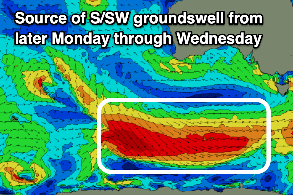
As touched on in the notes earlier in the week, a strengthening polar frontal progression firing up under the country from today will see a great, elongated fetch of gale to severe-gale W-W/NW winds pushing through our south-western swell window, strongest into tomorrow and Sunday morning, with an extended, moderate + sized S/SW groundswell due from later Monday but more so Tuesday, easing slowly Wednesday.
Middleton should come in at 3-5ft on Tuesday when the swell peaks, easing Wednesday with the Mid Coast unlikely to top 0.5-1ft.
Winds will slowly ease and tend more E-E/NE on Tuesday morning, though the South Coast will still be really lumpy and all over the place, while Wednesday looks the pick with a light W/NW-NW offshore ahead of a strengthening mid-latitude low that will bring strengthening SW winds through the day.
The mid-latitude low should generate a spike of S/SW swell for later Thursday and more so Friday morning with S’ly winds initially, possibly tending back W/NW on Friday but we’ll have a closer look at this and next weekend on Monday. Have a great weekend!
Comments
Hey Craig, does this SE wind look to persist beyond 5/6 April or will we be back to more regular Autumn patterns?