Windy period for the South Coast, tiny inside the gulf

South Australian forecast by Craig Brokensha (issued Wednesday March 26th)
Best Days: Friday morning for the keen South Coast, Wednesday morning South Coast
Features of the Forecast (tl;dr)
- Easing mix of swells tomorrow with mod-fresh E/SE winds (strong inside the gulf), tending S/SE into the PM
- Smaller Fri with a reinforcing mid-period SW swell, easing Sat
- Variable E/NE-NE winds Fri AM ahead of sea breezes
- Strengthening S/SE winds Sat with a late increase in windswell, peaking Sun with strong S/SE winds
- Easing S/SE windswell Mon with gusty S/SE-SE winds
- Small-mod sized mid-period S/SW swell Mon, with a stronger groundswell for Tue
- Light-mod SE winds Tue, with fresh sea breezes
- Easing S/SW groundswell Wed with N/NE tending S/SE-SE winds
Recap
The Mid Coast backed off to 1-1.5ft yesterday with a decent wave breaking all day under persistent offshore winds while Middleton saw lumpy 2-3ft surf under a cross-offshore wind.
Today, the Mid Coast has bottomed out with clean 1ft leftovers, while a mix of new SW swells are starting to show down South with stronger 3ft+ lines but with a moderate to fresh onshore wind. We should see the swell reaching 4-5ft across Middleton this afternoon with 1-1.5ft sets across the Mid Coast as winds strengthen from the S/SE.
This week and next (Mar 27 - Apr 4)
Today’s building mix of swells will peak this afternoon/evening and ease off through tomorrow as winds remain poor down South and moderate to fresh from the E/SE (strong at times across the Mid Coast), with a shift back to the S/SE due through the afternoon.

The Mid looks to ease from 1-1.5ft max with 3-4ft sets off Middleton, smaller Friday and to 1ft and 2ft+ respectively on the Mid and South Coasts.
A small reinforcing mid-period SW swell is due to keep wave heights steady all of Friday, generated by a weak fetch of W/NW winds currently moving in from the west, south of Western Australia.
A slight improvement in conditions is due down south on Friday as winds go variable E/NE-NE, bumpy into the afternoon with sea breezes.
Unfortunately a trough moving in from the west will combine with an inland low drifting south across the east of the country, bringing a reinforcement of strong S/SE winds into Saturday as the mid-period swell eases and localised windswell builds.
Winds will really kick up into the afternoon leading to building levels of windswell later that should peak Sunday to a stormy 3-5ft as winds persist from the S/SE.
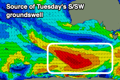
Monday will see easing levels of S/SE windswell as strong S/SE-SE winds persist, while at the same time some new mid-period SW swell should be on the build ahead of a stronger S/SW groundswell Tuesday.
The source of multiple pulses of swell for early to mid-next week will be a train of strengthening polar frontal systems from later this week, swinging under the country and skirting the polar shelf.
An initial weak frontal system should generate some mid-period SW swell for Monday (hidden under the localised S/SE windswell), while a stronger fetch of gale to severe-gale W/NW winds will produce a moderate + sized S/SW groundswell for Tuesday to 3-5ft across Middleton with the Mid Coast unlikely to top 1ft.
Local winds look to remain SE on Tuesday but with less strength, cleaner Wednesday as the groundswell eases, but we’ll confirm this Friday.
Comments
cheers craig, based on the surf today and the continued swell/wind forecast, glorious opportunities for the next 7 days on the limestone coast. no tourists till easter, either : )
Anyone surfed Goolwa over the last couple of days? How's the water quality now?