Good couple of days for the South Coast

South Australian forecast by Craig Brokensha (issued Monday March 17th)
Best Days: South Coast tomorrow morning and Wednesday, South Coast dawn or later morning Thursday, Mid Coast Friday but more so Sunday afternoon, South Coast Monday morning next week
Features of the Forecast (tl;dr)
- Easing S/SW swell tomorrow with N/NE tending E/SE winds
- New mid-period SW swell for Wed AM, ahead of a larger, less consistent S/SW groundswell into the late PM
- N tending N/NW-NW winds Wed
- Easing swell Thu with dawn N winds ahead of a gusty S/SW change, then tending variable ahead of sea breezes
- Moderate sized W/SW-SW swell building Fri, peaking in the PM, easing Sat
- E/SE tending S/SW winds Fri on the Mid, similar Sat
- Moderate + SW groundswell building Sun with E/NE tending E/SE winds, easing Mon with NE tending SE winds
Recap
Saturday offered the best waves on the South Coast with a hot, strengthening offshore wind and small swell that was best suited to the exposed beaches, but it was these exposed beaches that seem to have been impacted by a harmful red tide event, namely (Karenia brevis).
We’re currently investigating the possible source of respiratory issues and eye irritation, with it possibly being linked to an algal bloom in Investigator Strait late last week. If any one has any further information on the odour, colour and look of the ocean surface late last week and on the weekend that’d be greatly appreciated.
Yesterday, building levels of groundswell arrived with a strong onshore change, with today seeing a shift in winds to the east along with a large peak in S/SW swell energy. The Mid Coast is clean and peaky with tiny 1-1.5ft waves for the keen.
This week and weekend (Mar 18 - 23)
Following today’s onshore blow, we’ve got a good few days of surf ahead with an improvement in winds from tomorrow along with plenty more swell energy through the middle to end of the week.
Today’s SW groundswell is peaking and will start easing through tomorrow as winds swing N/NE down South and hold out of the E/SE into the afternoon. The South Coast should ease back from 4ft across Middleton with tiny 1ft waves inside the gulf.
Later in the day but more so Wednesday morning, a new mid-period SW swell is due ahead of a stronger S/SW groundswell into the late afternoon. This will be generated by a healthy polar low that’s currently south of Western Australia.
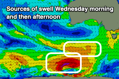
A good fetch of pre-frontal W/NW winds on the north-west flank of the low will generate the mid-period swell for Wednesday morning to 3-4ft across Middleton (1ft Mid Coast) while a fetch of severe-gale W’ly winds around the core of the low should produce the stronger but less consistent S/SW groundswell.
This should build to a less consistent 5-6ft later afternoon down South while remaining tiny inside the gulf and conditions look excellent most of the day for the South Coast with a N tending NW breeze due
Thursday is a tricky one, with a trough expected to bring a S/SW change shortly after dawn, but it will be offshore ahead of this and variable following it, with easing levels of S/SW swell from the 3-5ft range. The dawny looks best though it should be doable following the change though a little lumpy.
Thursday morning’s change will be associated with a weakening polar frontal system projecting up and into us, bringing with it a new, moderate sized mid-period W/SW-SW swell for Friday, peaking into the afternoon.
A persistent fetch of strong but slowly weakening W/SW-SW winds should produce a 1-2ft wave on the Mid Coast through the day, easing slowly Saturday from 1-1.5ft with Middleton coming in around 4ft at the peak Friday afternoon, also easing Saturday.
Local winds on Friday will swing back to the E/SE-SE through the morning, favouring the Mid Coast, though afternoon sea breezes will spoil the peak of swell.
Saturday looks similar with a shift in winds back to the E/NE possible on Sunday, cleaning up the South Coast a little.
At the same time, a moderate + sized SW groundswell is due into the afternoon Sunday and Monday morning, produced by a strong low moving under the country later this week, but we’ll have a closer look at this Wednesday.
Comments
FYI all comments re: skin/eye irritations have been moved over to a new article: https://www.swellnet.com/news/swellnet-analysis/2025/03/17/south-oz-surf...
Last couple of days been pretty good on the Mid.
Yeah looks it, coming in cold and didn't see the swell sources for the little runners.
Yep, the mid was good yesterday morning.
Disabled Surfing Australia will be at Moana on Sunday.
If you know anyone who would like to surf but struggles for any reason go and sign up through the Facebook page.
And if you want to lend a hand we'd love to have you - you don't have to rip, just be capable of grabbing anyone that falls in the drink. You can sign up on the day at Moana SLSC at midday :)