Strong run of groundswell ahead; mid-late next week looking best down south

South Australian Forecast by Ben Matson (issued Friday March 14th)
Features of the Forecast (tl;dr)
- Smaller surf Sat with generally light winds and sea breezes, best at Victor Harbor
- Strong onshore winds ruining a building swell Sun (only small on the Mid due to the direction)
- Low/mod chance for small clean waves on the Mid Mon thru' Thurs (swell direction prob too S, keep expectations low)
- Large surf Mon but with poor conditions under fresh onshores, easing and improving Tues with light winds
- Wed/Thurs/Fri looking best down south with light winds and a strong, easing swell
- More swell due in the following week
Recap
The Mid saw small lines of groundswell for much of Thursday, generally too small to ride and with early offshore winds ahead of afternoon sea breezes. Size has eased back this morning, though seems to have perked back up to 0.5-1ft this afternoon (albeit wobbly under the sea breeze). Victor picked up a building swell on Thursday that reached 2-3ft at Middleton, before easing from a similar size this morning. Onshore winds created a few issues on Thursday but this morning saw better conditions with light variable tending offshore winds ahead of afternoon sea breezes.
This weekend (Mar 15 - 16)
A weak trough will push across the region on Saturday, swinging light/mod N’ly winds around to the south during the day - though no major strength is expected, so conditions shouldn’t be too adversely impacted.
As for surf, today’s swell will ease into Saturday, so don’t expect anything worthwhile on the Mid, we’ll most likely just see tiny teaser lines again. Expect smaller surf down south with fun waves at exposed beaches early on whilst winds are favourable.
A vigorous front is expected to cross the coast on Sunday morning, with perhaps a brief window of light/mod W’ly winds early before gusty S/SW winds kick in by mid-morning.
We’ll see a small groundswell on the Mid accompanied by some local windswell, though not much because of the southerly bias in the local wind direction (limiting the upstream fetch length). Average 1-2ft waves are the most likely scenario through the day.
Down south, apart from a possible flukey window of lighter winds at dawn, we’ll see large surf building by the afternoon (smaller earlier) under strengthening onshores. So it’s really not looking terribly exciting for surf potential as there won’t be anywhere handling the conditions.
Next week (Mar 17 onwards)
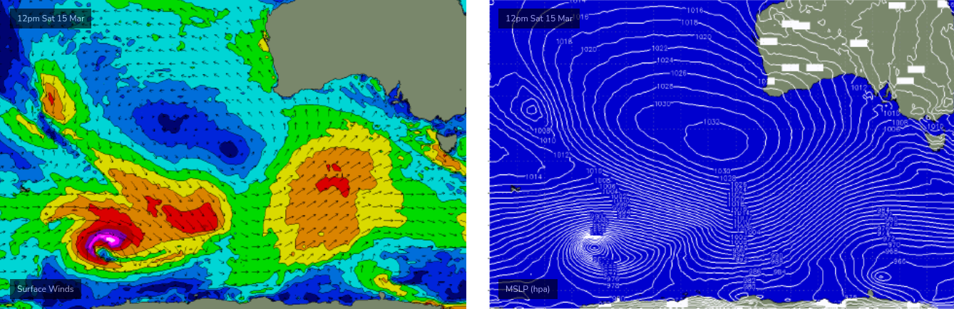
We’ve got a solid run of autumn swell lining up for the state next week, thanks to a powerful conveyor belt of Southern Ocean fronts and lows generating overlapping groundswells that’ll arrive from Sunday thru’ Friday.
However, it looks like there’ll be a touch more south in the swell direction than is ideal for the Mid Coast (see chart below), which means we may not see much size in the gulf. This is a shame as winds are looking good, initially moderate to fresh SE on Monday and then light and variable from Tuesday thru’ Friday under the influence of a broad ridge of high pressure.
There’s always a chance for a few small waves to show across the reefs with the influence of the incoming tide, but for now I’d keep your expectations low for anything more than a super inconsistent 1-2ft.
Victor Harbor will see poor conditions on Monday under fresh SE winds, but the rest of the week looks much better as the high pressure system also favours light variable winds from Tuesday right into the adjoining weekend.
Monday will see large bumpy waves in the 6ft, almost 6-8ft range at exposed spots, Tuesday should see improving 4-5ft surf at Middleton (though likely still some surface lumpiness) but Wednesday is probably the pick of the week with a new groundswell expected to push wave heights back up into the 4-6ft range, sourced from an intense polar low skirting the ice shelf on Sunday.
Easing size is then due from Thursday and Friday, which should also generate great surf conditions under the weak pressure gradient.
The longer term outlook suggests a quieter weekend ahead of a renewal of activity in the following week as the Southern Ocean storm track fires up again.
See you Monday!