Good run for the South Coast

South Australian forecast by Craig Brokensha (issued Friday March 7th)
Best Days: Today Mid Coast, South Coast all weekend, South Coast Monday afternoon, possibly South Coast early Tuesday and Wednesday mornings, South Coast Friday morning
Features of the Forecast (tl;dr)
- Easing mix of swells tomorrow with N/NE winds, tending E/NE then possibly E/SE through the PM
- Small, flukey SW groundswell Sun with fresh N/NE winds, tending variable ahead of possible late sea breezes
- Small to tiny Mon AM, with a mdoerate sized, inconsistent SW groundswell later in the day, peaking Tue AM
- N/NE winds Mon, tending variable
- Variable tending SW winds Tue with variable S/SE winds Wed AM
- Moderate sized SW groundswell for later Thu, peaking Fri with N/NE tending N/NW winds ahead of a SW change
Recap
Our new W/SW swell started to show yesterday morning with clean, windy 1-1.5ft sets on the Mid Coast, pulsing to a nice 2ft with the incoming tide through the afternoon.
This morning early was the pick with the rising tide and fun, 2ft sets but the swell is now slowing with the outgoing.
The South Coast saw a chunky increase in S’ly windswell yesterday, improving today with winds swinging more E and easing along with some new mid-period SW energy.
This weekend and next week (Mar 8 - 14)
Today’s mix of swells are due to ease over the weekend with conditions being great for the exposed beaches down South as high pressure pushes slowly east, into the Tasman Sea.
Middleton looks to ease back to 2ft tomorrow with a great N/NE offshore, tending slowly E/NE then E/SE later throughout the day. The Mid Coast looks tiny and easing from 1ft+.
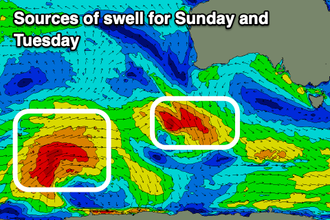
On Sunday, a less than ideal SW groundswell is showing on the charts, with it generated by the remnants of Tropical Cyclone Garance forming into a tight but poorly structured low to the south-west of Western Australia.
This low generated a pre-frontal fetch of N/NW gales aimed away from our swell window with the fetch tweaking more W/NW-NW through today but still being poorly aligned while tracking south-east towards the polar shelf.
I wouldn’t expect much over 1-2ft from this source off Middleton but a fresh N/NE breeze will favour the magnets, tending variable ahead of late possible sea breezes.
Monday will be clean again down South with a N/NE offshore, holding most of the day but the swell will be small to tiny through the morning. Into the late afternoon but more so Tuesday, our more reliable but inconsistent groundswell from a strong polar low that traversed the Heard Island region is expected.
As touched on in Wednesday’s update, a great but distant fetch of severe-gale W’ly winds were generated, weakening while tacking more east-northeast towards Western Australia yesterday, leaving the groundswell to arrive Monday afternoon but peak Tuesday morning.
Middleton should build to 2-3ft by dark on Monday with Tuesday morning coming in at 3ft to occasionally 4ft and the Mid Coast should see 1ft waves.
Local winds are tricky and possibly variable Tuesday morning, but shifting SW through the day with easing levels of swell and S-S/SE winds though without much strength Wednesday.
Into the end of the week, another long-range but moderate sized SW groundswell is due, produced by a healthy polar low forming to the east of the Heard Island region on the weekend.
This looks to be met with N/NE tending N/NW winds Friday ahead of an afternoon change. More on this Monday. Have a great weekend!
Comments
Cameras are useless down south at the moment.